- Difficulty Intermediate
- Time 2 hours
- Round-Trip 4.5km
- Elevation Gain 230 meters
- Season May - October
- Camping No
- From Vancouver 2 hours
- Public Transit No
- Dog Friendly Yes
The Crater Rim Trail is located in the Whistler Interpretive Forest and loops around Loggers Lake passing several scenic views and through a beautiful forest. Loggers Lake is situated in an extinct volcano and the Crater Rim Trail passes around the upper ridges that surround the lake.
The trail begins next to the wooden signboard next to the gravel road and across from a small parking area. If you are unable to get parked at this tiny parking lot, you can park back down the road near where you crossed the one-way bridge in a designated parking area, then walk up the Riverside Trail along the west side of the Cheakamus River. This adds additional distance and time to your hike but the Riverside Trail is scenic, passes a suspension bridge, and is a relatively easy walk.
From the start of the trail, follow the rocky trail uphill towards Loggers Lake as it quickly gains elevation. Along the way, there are several views that look back down towards the valley. As the trail levels, watch for a small trail with a blue sign on the left marked Crater Rim Trail and go left, following this trail uphill. The sign says that the Crater Rim Trail is 6km but we found that to be a bit generous and that the trail was closer to 4.5km to complete the loop, returning to the small parking lot.
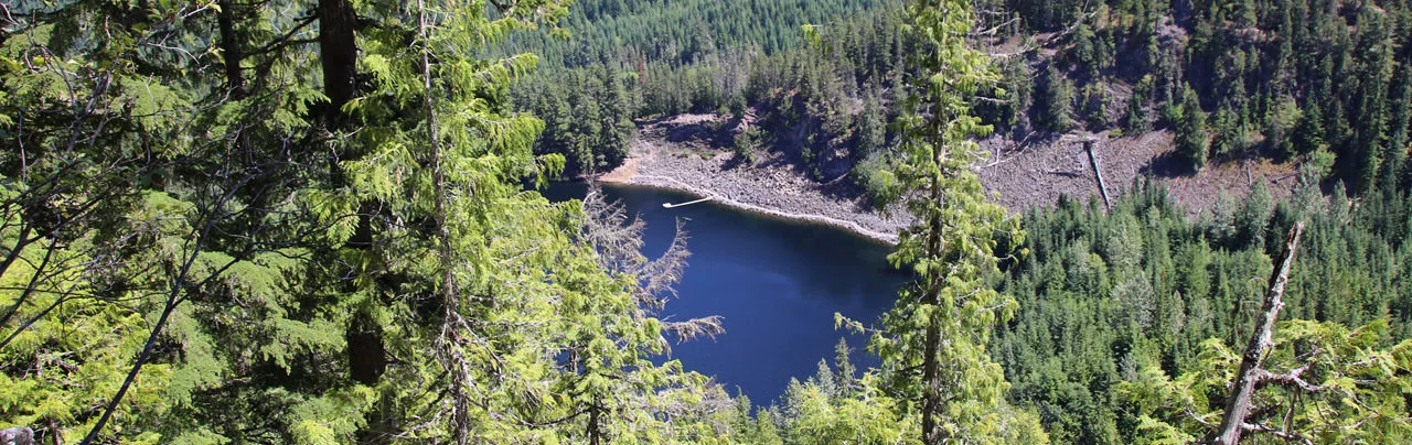
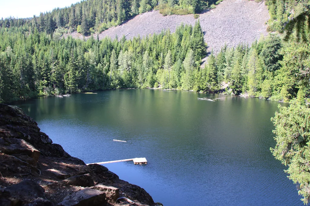
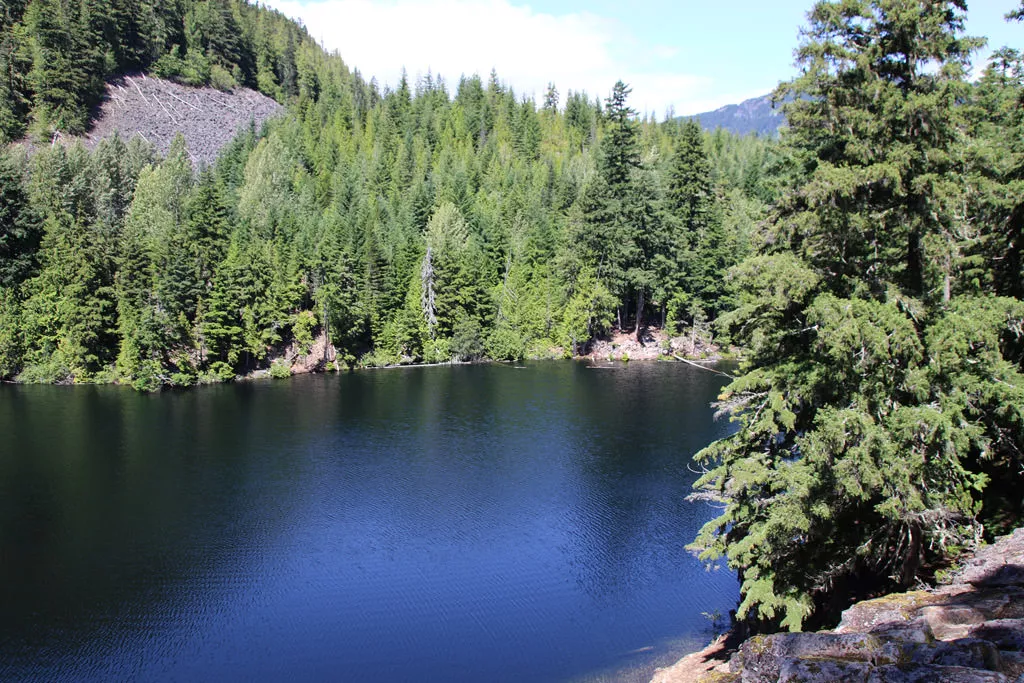
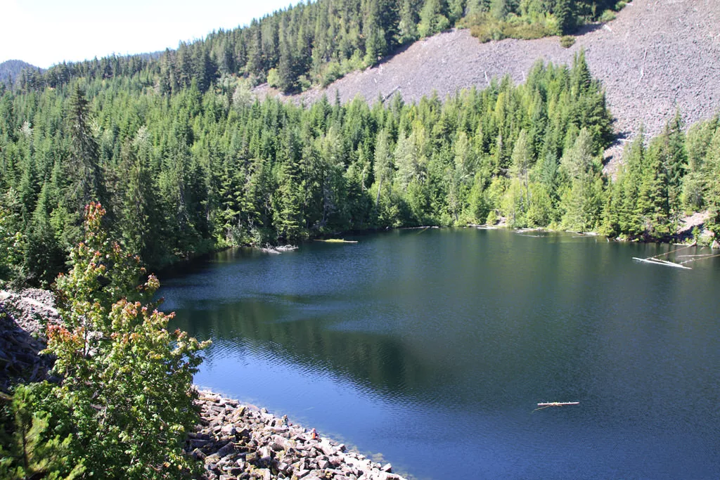
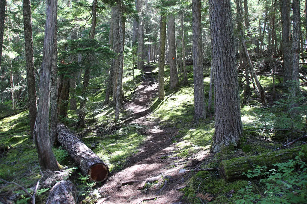
Follow the trail as it heads uphill into the forest and is marked with yellow diamond markers on the trees. Within minutes, you reach a clearing where you look down onto Loggers Lake for one of the most scenic views of the area. Loggers Lake is known to be one of the warmest lakes in Whistler as the rocky walls of the volcano that surround the lake protect it from the cooler air and the lake is not glacier fed like many other lakes in the region.
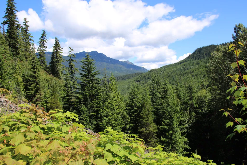
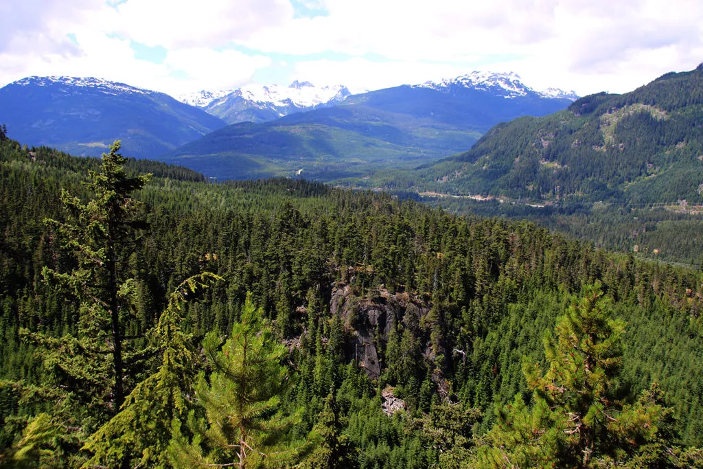
Continue following the trail as it climbs further before levelling and following a narrow path high above the vegetation below. The trail then veers right and follows along a ridge, where there both sides of the trail have drop-offs. At the first junction, continue going straight but look for the occasional openings on the left side of the trail to enjoy scenic mountain views looking southeast towards Garibaldi Provincial Park.
Upon reaching another junction that has no parkings on the wooden pole, go straight and continue up the hill where there is another junction a short distance further. At this junction that's well marked with a blue sign, go right onto the Crater Rim Trail and continue uphill as the trail veers right and climbs to the highest point. There is a viewpoint not much further where Loggers Lake can be seen far below. A few more minutes of climbing and the trail leaves and passes through a second generation forest. The trail is fairly flat with small inclines and declines for quite some distance, as you quickly move through this section of the route.
Eventually, you reach another viewpoint that looks northeast over the valley towards the Sea To Sky Highway in the distance. After this point, the trail descends steeply through a series of switchbacks. Carefully make your way down the hill as the loose rocks can be slippery on several sections.
The trail reaches a rockslide area where it crosses over well worn rocks where other hikes have stepped. Enter the forest on the other side of the rockslide and continue up and down a couple of tiny hills before the trail reaches an old logging road where it widens considerably. Follow the wide trail and within minutes, you reach a junction with the Ridge Trail. Go right onto the wide, gravel road and follow this back towards Loggers Lake. This route is shared with mountain bikers and hikers.
When the trail reaches a junction next to an outhouse, go left and following the wide trail around Loggers Lake, back towards where you began. Watch for a small trail on the right side that leads to Loggers Lake and follow this route down to the water. There is a path next to the lake that leads to a makeshift wooden dock. After hiking the Crater Rim Trail on a hot summer's day, the lake is a perfect place to take a swim to cool down before heading back to the parking lot.
After enjoying Loggers Lake, return to the main trail and go right heading back past the junction that you passes at the start of the hiker earlier. Following the wide trail back down the rocky hill and return to the parking area. If you had to park further down the Cheakamus River, pass through the parking lot and return via the Riverside Trail.
How to get to Crater Rim Trail
Estimated Driving Time from Vancouver
2 hours
The Crater Rim Trail is located in the Whistler Interpretive Forest near Function Junction.
Parking
Parking is very limited and only fits about 6-8 cars along the Cheakamus Forestry Road near the trailhead to Loggers Lake and the Crater Rim Trail. There are several other areas to park further down the trail near the beginning of the gravel road and then you will have to walk up the Riverside Trail to the trailhead, an easy walk of up to 2km, depending where you park. Ensure to park in designated parking areas and do not block the road or you will be towed.
From Whistler Village
Drive south on the Sea To Sky Highway and turn left at the traffic lights at Function Junction to the Whistler Interpretive Forest. Drive for less than 1km and, just before crossing a bridge, turn left onto the gravel Cheakamus Lake Road. Immediately at a junction, turn right and cross a one-way bridge and follow the gravel road, noting your mileage. It's about 2km to the small parking area for Loggers Lake and there is limited signage. There will be a small parking area on the left and a wooden signboard to the right of the road where the trail begins. If there is no parking, drive back down the road to one of the parking areas near the bridge and walk up the Riverside Trail.
From Vancouver
The Crater Rim Trail and Loggers Lake are located in the Whistler area. From Vancouver, drive to Highway #1 and heading westbound and drive through West Vancouver heading towards Horseshoe Bay. Just before Horseshoe Bay, merge with Highway #99 The Sea To Sky Highway heading Northbound to Squamish and Whistler. Drive the scenic route, passing through Squamish and continuing to Whistler.
At the first set of traffic lights in Whistler (at Function Junction), turn right. Drive less than 1km and turn left onto the gravel Cheakamus Lake Road (if you cross a bridge, you've missed the turn off). Almost right away, turn right at a junction to Loggers Lake and cross a one-way bridge over the Cheakamus River. Note the mileage on your odometer and drive about 2km up the gravel road to a small parking area on the left. The trail begins at a wooden sign on the opposite side of the road from the parking lot.
View a map of Driving directions to Crater Rim Trail.

Although we try to keep information as current as possible, www.vancouvertrails.com makes no warranty or representation as to the availability, quality, fitness for purpose, conditions or accuracy of the information provided with respect to this trail or trails. The information provided herein is further subject to our Terms of Use.
Comments
Add Comment View All Comments