- Difficulty Intermediate
- Time 2 hours
- Round-Trip 2.4km
- Elevation Gain 160 meters
- Season February - October
- Camping No
- From Vancouver 45 minutes
- Public Transit No
- Dog Friendly No
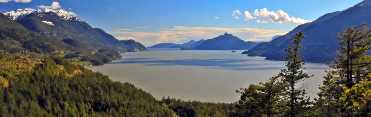
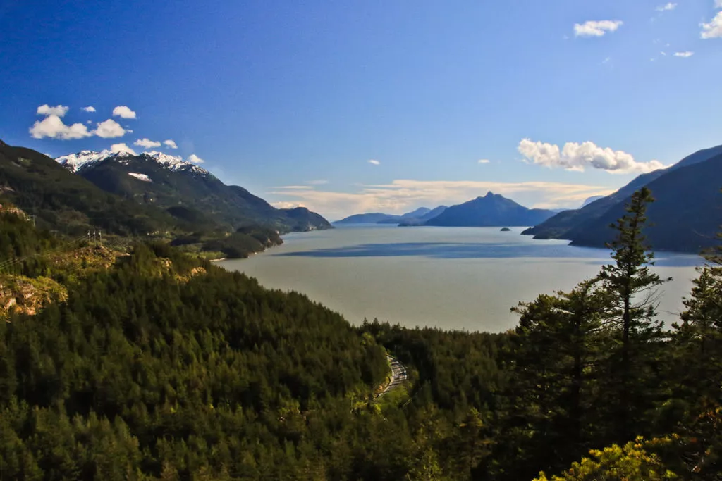
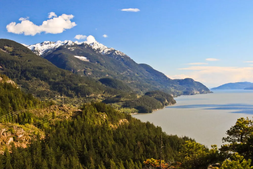
Located just south of Squamish along the Sea To Sky Highway, Murrin Provincial Park is home to the popular Browning Lake, offering a great place to swim and have a family picnic during the summer months. The park has several climbing walls and there is a steep hiking trail that climbs up to Jurassic Ridge and the Quercus Viewpoint, both providing spectacular views overlooking Howe Sound.
Even though the distance is not long, the rating for this trail to the viewpoint is Intermediate due to it being quite steep. This trail description assumes you will hike up to Jurassic Ridge, where the descent from the ridge has a couple of rope assists and steep, open rock sections where you will have to use caution. If you bypass Jurassic Ridge and just complete the Murrin Loop Trail, the elevation gain will 130m total and distance 2km. The route is best done in a counter-clockwise direction.
From the parking lot, follow the trail past the map of the park and walk towards Browning Lake, following the path through the beach areas. This beach area is busy during the warmer months of the year but you will soon leave the lakeside and hike up a trail, away from the crowds. After passing the beach area, watch for a sign and a trail on the right, marking the route to Jurassic Ridge and the Quercus Viewpoint.
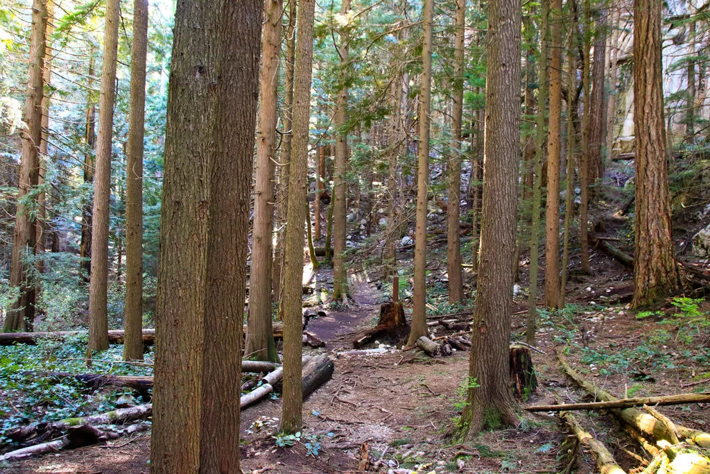
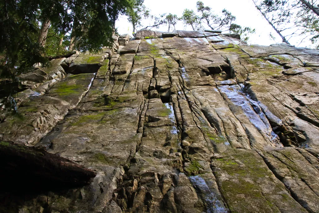
Leave the Browning Lake area and begin hiking up the hill briefly before descending and arriving at another junction in the forest. At the junction, go right and follow the Murrin Loop Trail in a counter clockwise direction. The trail climbs very steeply, first along dirt and then up wood steps, sometimes which are quite muddy during the off-season months. Admire the large rock overhangs that precariously sit above the trail as you stop to catch your breath before continuing uphill.
Not too long into your hike, the trail reaches a junction. Go straight towards the viewpoint as the trail leads out of the forest and climbs up onto the rock, arriving at a wooden bench. Continue past the bench to the end of the rocky bluff where a spectacular view of Howe Sound awaits. Known as the Quercus Viewpoint, this is a spectacular view as you can see straight out into Howe Sound, look down towards Browning Lake, and up towards some of the region's mountains.
After enjoying the viewpoint, walk back to the trail and return to the junction, this time going the other direction to continue around the Loop Trail. A short distance further and you reach another junction with a sign pointing to the right to Jurassic Ridge. If you want a short hike, go left and continue along the Murrin Loop Trail, which will take you back down to the lake. For a longer route, go right and begin the steep hike up to Jurassic Ridge.
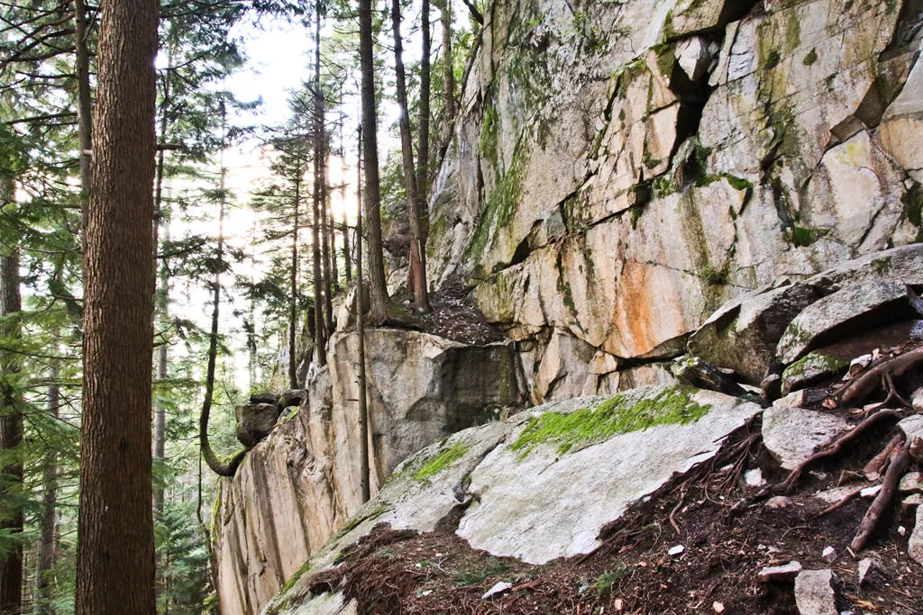
The trail climbs quite relentlessly for about 150m of elevation gain for levelling. Carefully step down over a rock and follow the route as it winds its way through the trees, offering the occasional glimpses of Howe Sound between the trees. Use a rope assist to descend a rocky section, then follow the trail through a forest as it sharply veers left and follows a worn path up onto a rocky bluff. From this point, there are a few half-decent views looking west over Howe Sound towards the old Woodfibre Mill.
Carefully follow the trail markers on the trees as you begin to descend down the rocky hill. A short distance downhill, you arrive at the first of one of the spectacular views along Jurassic Ridge. This view looks out towards Howe Sound and is similar to the Quercus Viewpoint but at a higher elevation.
Use a second rope to assist you in descending down the smooth rocky route, carefully watching your step. The route descends steeply to another spectacular viewpoint. After this viewpoint, follow the trail markers downhill as the route continues its steep descent. Eventually, you arrive at a spot where steel rods are embedded into the rock as a ladder. Climb down the ladder and descend along the trail a short distance further, into the forest and to a sign at a junction.
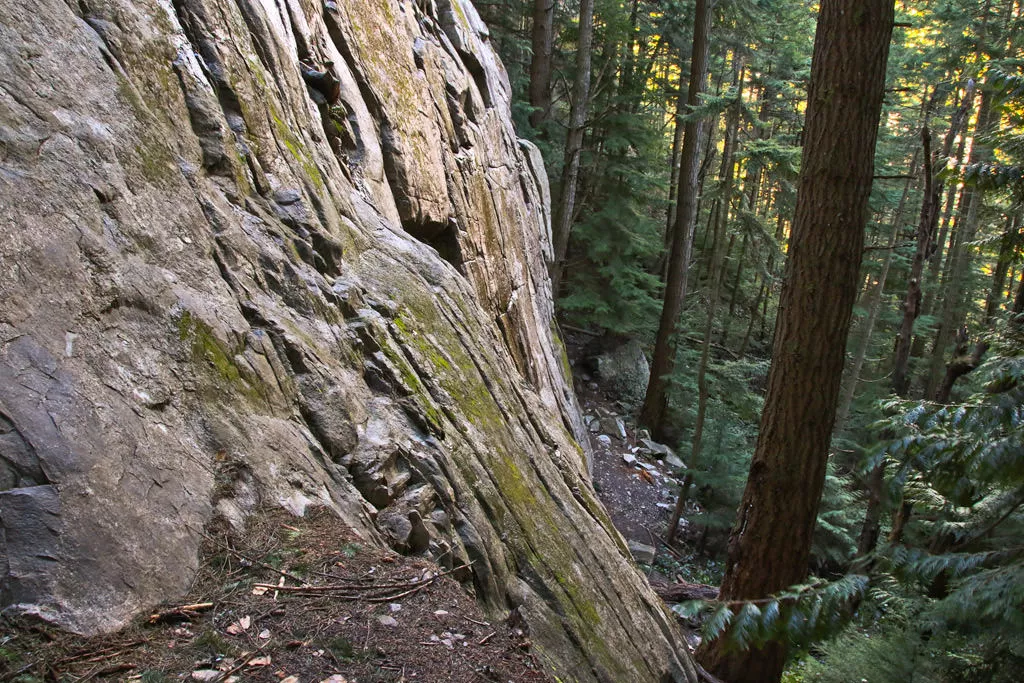
Arriving back in the forest at the junction, make sure you go left at this junction to start hiking back to the lake (going right is a much longer route). A short distance further and you arrive at another junction near a bridge. This is where the Murrin Loop Trail meets, if you had not done the Jurassic Ridge section. Go right at this junction and follow the trail as it gradually descends through the forest as you make your way past a couple of climbing areas. Cross over a small wooden bridge, then descend down a hill between two rock faces and a short distance further, you arrive at a second viewpoint with a bench looking towards Howe Sound.
Continue hiking down the steep stairs, passing another climbing area to your left until the trail reaches another junction. To return to Browning Lake, go left at the junction and walk through the forest, past the junction where you started the loop, over the small hill and back down to the lake trail.
For an additional walk, you can also continue walking around the Browning Lake Loop to return to the parking lot a different way but walking along the trail next to the highway is not the most peaceful experience.
How to get to Murrin Loop and Jurassic Ridge Trail
Estimated Driving Time from Vancouver
45 minutes
Murrin Provincial Park is located along the Sea To Sky Highway, just south of Squamish. Browning Lake is recognizable as it's right next to the highway.
To drive to Murrin Provincial Park from Vancouver, drive to Georgia Street downtown and then head westbound, crossing the Lions Gate Bridge. Stay to the left and follow the exit into West Vancouver. At the traffic light, turn right and drive up Taylor Way to Highway #1, then turn left and drive onto Highway #1 heading westbound to Horseshoe Bay.
If you're driving from the eastern part of Vancouver or another suburb, make your way to Highway #1 and enter the highway heading westbound. Cross the Iron Workers Memorial (Second Narrows) bridge and continue heading westbound towards Horseshoe Bay.
Just before reaching Horseshoe Bay, watch for signs for Highway 99: The Sea To Sky Highway and merge onto it heading northbound towards Whistler. Continue driving along the highway for just over 30km and watch for signs for Murrin Provincial Park. When you see the lake on your left, pull into the left turn lane and wait until you are able to cross the highway to the parking lot, being very careful to do so.
If you miss the turnoff, continue to the Shannon Falls turn off and turn around there before heading back along the highway.
View a map of Driving directions to Murrin Loop and Jurassic Ridge Trail.

Although we try to keep information as current as possible, www.vancouvertrails.com makes no warranty or representation as to the availability, quality, fitness for purpose, conditions or accuracy of the information provided with respect to this trail or trails. The information provided herein is further subject to our Terms of Use.
Comments
Add Comment View All Comments