View High Falls Creek Description | Add Comment
VanHiker from Burnaby writes:
Not overly long or hard. The route listed here is the full route but there is a shorter route that is 8.5km. In fact, I accidently took this shorter route. If you are following the trail markers, you will likely end up cutting off a decent chunk of the forest and forest service road. No snow except one tiny section of the FSR but no spikes required.
Recommend going on a day when it hasn't rained for a bit so the rocks aren't slippery. It's a relatively easy route though, no danger involved.
Posted: March 26, 2021 05:02:14 PM PST
A from lower mainland writes:
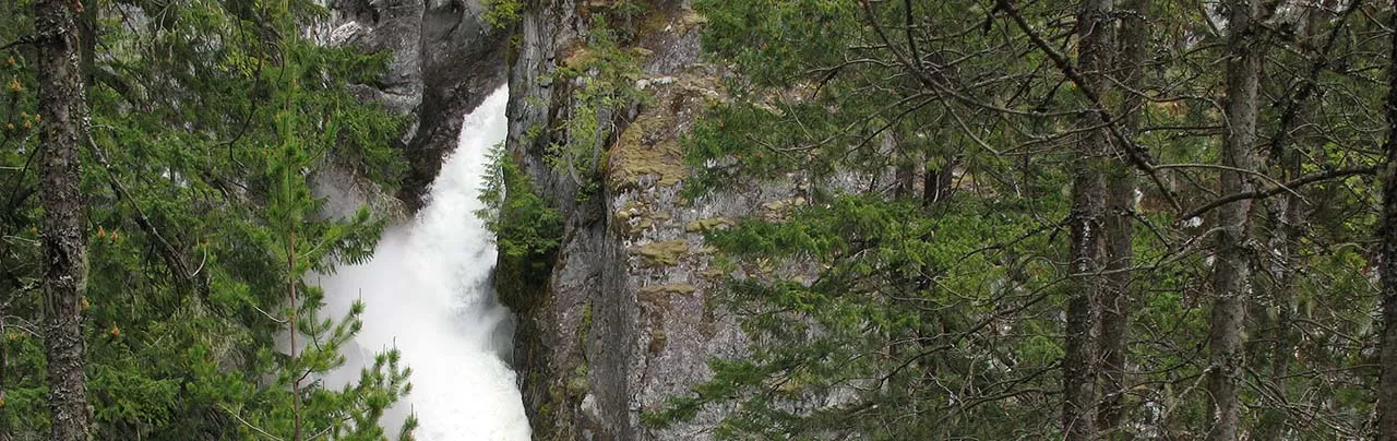
The views at the top was amazing, the waterfall was great. Probably should be rated as hard. The whole trail was not very well marked and there was no sign at the trail head. Definitely not recommended for those scared of heights. Many sections were very steep but thankfully there were ropes to help. We didn't take the round trip, instead we climbed down the same route it was really slippery and hard. Still don't let this stop you! Even my 8 year old brother made it!
Posted: September 1, 2020 04:12:47 PM PST
crossover from Vancouver, BC writes:
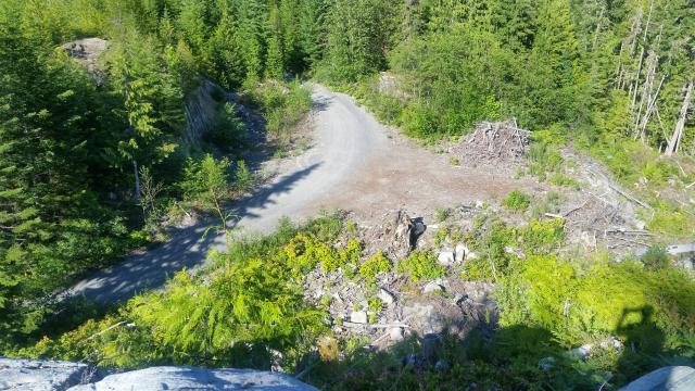
Hiked on 2019.05.11. The trailhead was not clearly signed but if you follow the directions on this website, you should have no trouble finding it. The trail was very interesting with chains and cables helping you in certain areas (similar to climbing the Chief but on a lesser scale). The High Falls and the views of the valley was beautiful. However, i would strongly suggest backtracking to your car via the same route after the final viewpoint of the fall (indicated by a sign that says "Viewpoint-No Exit") instead of doing a loop (and I usually prefer loops over in-and-out). This is because after this viewpioint, the trail markers are sparse. We reached a junction and got confused because there were markers on both the left and right hand side. We chose to go left because our GPS indicated that was the way to go. We eventually hit the service road and needed to walk another 5-6 km of loose rock with sometimes steep grades. The dust caused by moving vehicles was not enjoyable either. Btw, bring lots of water because there is no water source tp refill your bottle.

Posted: May 13, 2019 07:28:11 AM PST
Damien from Vancouver writes:
Finding the trailhead was easy as long as you have an offline app like maps.me.
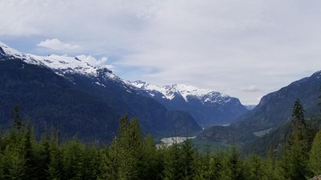
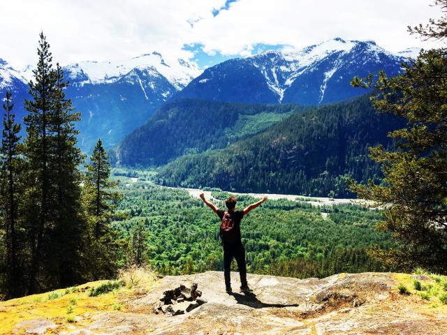
We liked hiking up this trail because you get amazing views on the valley, glaciers, and waterfall.
However going down the logging road and back to the trailhead along FSR is quite boring.
I wouldn't do this hike again. We only met 2 other hiker groups.
Posted: September 30, 2018 02:57:26 PM PST
Simon from Warsaw writes:
Trailhead is not marked, we were riding around with GPS looking for anything resembling the trail and failed.
But we found a camping, 500m further away from where trailhead was supposed to be. It had a WORKING AUTOMATIC HAND SANITIZER - imagine that, there is someone filling in and maintaining a hand sanitizer there but its too hard to properly mark the trailhead once. Two stars for the hand sanitizer.
Posted: September 4, 2018 11:23:53 PM PST
Emily from Vancouver writes:
I did this on July 28, 2018. The trail head was quite easy to find with all the other instructions on the website. Do be prepared ahead of time though as there is no service in the area.
The rope sections were fine and I didn't find the trail to be scary. Just don't go near the edge though. If you're really afraid of heights, you might not like portions of this trail though. When you see the waterfall lookout, enjoy the moment as this is your only view of the waterfall.
There were orange trail markers nailed into trees for some of it (especially near the end of the trail), although at one point the trail visibly splits into two. We went left, which seemed to be fine, but there was also a trail marker on the path to the right. Not sure where that one goes? The path getting into the boulder field was pretty much non-existent and we had to make our way through lots of berry bushes (fortunately, mostly non-prickly ones). Perhaps we lost it somewhere? There are lots of little cairns in the boulder field to guide you through. We took the logging road down, which had nice views as long as logging roads go, but it is quite a long walk back. It took us about 3 hours and 45 minutes in total, but we were moving quite slowly and it was hot and humid. You could easily jog parts of the logging road as well. There isn't any water on the hike, so make sure you bring enough.
Posted: July 30, 2018 01:44:43 PM PST
Christopher from Tsawwassen writes:
Here's an honest assessment of the hike.First off you're unlikely to fall off the edge, Just stick to the inside edge of the trail & you should be fine. Don't wear flip flops, there is a lot of pulling yourself up by chains & ropes similar to the Chief. The trail is not marked well at all, I wished I had brought surveyors tape with me I would have fixed the missing sections. Stick to the trail & eventually you will get to an area that has been logged, Stop. If you look to the left you will see a clearcut area and a rock face that's where you want to go. There is no trail and no flagging, but you are only 10 min from the logging road.i posted some photos of the logging road from above on the rocks, like I said you're on your own for figuring out how to get there. The walk back down is not bad, at least there's scenery.


Posted: June 24, 2018 07:31:47 PM PST
Ali from Surrey writes:
A decent hike that offers a good workout and amazing views of the Squamish Valley and the Falls. The trail is not difficult to follow. If you decide to make your way down using the logging road, you will be rewarded with more spectacular views, but at the expanse of inhaling a lot of dust, caused by the vehicles driving past you.
Posted: June 23, 2018 10:37:14 PM PST
Nick D. from Vancouver writes:
I'm new to the area and I did this this hike two weeks ago (before I did part of the Chief last week, which was a lot more strenuous and had aspects of similar features with rope/chain). That said, I felt this hike was an adventure! Some comments noted it was hard to find the trail head. If you pass the pump house (a large white building as you are crossing a bridge on a gravel road), then go over the next bridge after that one and park just after on the left - directly across the road you'll see a small scratched out white sign on a tree. That's the trail head.
I had never done a hike like this before where, in short order, the trail ended in a cliff face (head up to the right) and with places thereafter to scramble up and areas with chains and ropes to pull yourself up - so exciting! I'm relatively risk averse, so yes, the sheer cliffs could be dangerous, but if you use common sense and take your time, you will be okay if you are in good enough physical shape to climb up the parts required. That said, the trail is marginally marked up at best (even with tape on the trees) through the point past where you see the waterfall. After that, you climb higher, see a beautiful vista, then after reach an open area before entering the forrest (picture two). If you keep going, the trail splits and you can go to the right to get a view of the falls from above, all good. If you have any aversion to getting lost, turn back the way you came at that point, as the "trail" becomes poorly marked if you keep going. I did and got off the trail even with really trying to take my time and having an app on my phone showing my location on the trail; however, happened to make my way back on the trail.
Eventually, you end up in a newer growth forest where the marking is better. This next part is hard to explain. If you look at the map on this site, imagine the route resembles a gnome with a pointy hat, his arms extended to the right, a narrow point of his wrist, then this hand extended flat farther to the right. The new forrest part of the trail reaches a gravel logging road at the "wrist" of the gnome. I went to the left, following that road down, not to the right where the boulder field is located...you're on your own there from past comments.
The gravel road down had some parts off to the left with some absolutely amazing views, of which a photograph will not capture the glory of it all! Yeah, you could drive past the trail head and just get up there by car, but it's pretty rewarding after an adventurous hike, especially if you're not used to the grandeur of this area. Grade going down was steep at points. Back on the road it was dusty when cars drove by, so if that bothers you, bring a bandana. I didn't see a soul until the part where I hit the logging road and thought this hike was a special experience on a beautiful day. You can soak your feet in the stream at the end, but it was icy when I tried to do so...probably better for the summer/fall. I can't wait to go back to this one for sure to better mark the trail with some tape and get better pics/video of the views!

Posted: May 4, 2018 10:56:02 PM PST
Joseph from Vancouver writes:
There is no sign indicating the trail head. Also the trail is not clearly marked and it is very easy to get lost. Whoever maintains this trail is dropping the ball pretty hard and are just begging for people to get lost. I think this is dangerous and irresponsible. I
Posted: September 29, 2017 01:08:12 PM PST
Zara Dureno from Squamish writes:
Did this hike near the end of August... at first I thought it was silly that people were getting lost because the first 3/4 of the trail is really well marked and easy to follow... HOWEVER, the top of the trail is where things get confusing. I ended up getting lost for two hours. I found another group hiking and they had been lost for 4 hours. I eventually had to bushwhack my way through trees and prickly bushes and then scale my way down a cliff to get to the logging road because I was desperate. The views from the logging road are gorgeous (the views from the rest of the trail are nice but not extraordinary) but you could easily drive up the logging road in pretty much any car to see those views. I recommend hiking this trail to the 3rd viewpoint and then heading down the way you came and going up the logging road in your car (beware of 18% inclines). Also, I saw a coyote and that scared me a bit.
Posted: September 1, 2017 11:21:46 AM PST
Amanda from Toronto (now Vancouver) writes:
This hike is INTENSE. Right of the bat, get ready to get lost. We thought we stopped at the right bridge (we didn't know if we passed the pump house or not), turns out we didn't. We walked around and finally found someone who was a rafting guide. He confirmed we were lost. Got back in the car and finally (obviously) saw the pump house. Drove passed it over a bridge (still not the bridge to stop at) then over another bridge, we stopped there and parked and walked over it. It's directly to the right of the path (by the way you can drive over that bridge and park on the other side, there is way more space). We weren't sure if it was the trailhead or not because we thought we had to walk a short distance over the bridge, also the path was marked with a white sign that was scribbled over. We ran into other people who happened to park at the same time as us, the guy said he had done it before and it was that way. Not many cars or people on this trail so we were lucky. We walked into the forest and came straight up to a cliff face. We took the path of least resistance, which was wrong. We ran into the guy again and he told us it was to the left up the narrow rocky path. From then on in it was uphill with chains and ropes to help you stabilize. It's almost like rock climbing but hiking? After the intense climbing beside a cliff, that if you slipped and fell, it would be certain death. You finally get to the top and.... Grizzly Bear. Bear spray is a must. We freaked out a bit because we crossed paths with a cub. Picked up some rocks and started banging them together and sang 'The Wheels on the Bus'. After we deemed the trail safe, which was based on nothing in particular, we just kinda gave up. The walk down from there was painful on the ankles and knees, downhill with rocks. Finally we got to some shade and flat land. We walked back to the car (the trail brings you back). We went under the bridge and bathed our dusty legs and stinky feet and hands. Then I noticed salmon swimming upstream. We walked over and I stood knee deep while salmon swam up to me. Later I looked them up (and sent them a friend request obviously) they were Pink salmon and Chum. LOVED this hike. It made me see trails in a whole new light... and reminded me of the reality of bears.


Posted: August 27, 2017 08:31:49 PM PST
Kyle Dillon from Burnaby writes:
I did this hike with my girlfriend and my dog on the 28th of May 2017. This is a rewarding hike but it is also a HOT hike. Especially the logging road return leg. To be honest I would recommend simply back tracking after reaching the 3rd viewpoint and descending this way. The hike down the logging road is long, hot and hard on the feet, even with good footwear. As for dogs... As long as you are well practiced in hiking with your pooch you will be fine bringing them. I have a basic harness for my dog and had to carry him about 4 times total over the most vertical sections. He weighs ~45 pounds. It was a much easier ascent and decent with the dog than say, the chief peak 2 or 3, for example. The biggest problem for a dog though, is that there is absolutely NO running water on this hike. We went on a 27C day and that was the absolute limit of my dogs heat resistance. I would NOT recommend taking your dog on this hike past mid-day in heat above 25C. Do not bring your dog if you are a causal hiker. You WILL need to carry them WHILE climbing to complete this hike. Bring lots of water!


Posted: July 8, 2017 04:56:24 PM PST
Diana from Surrey writes:
Did this hike on June 3 with 2 other girls. If you are coming from the Vancouver direction, trail head is after you cross the little bridge on the right side. There is a silver metal sign high up with scratches where the writing is supposed to be but we just followed another group that was going up. It was fairly easy following the trail markers till the bouldering field. We did pay close attention to make sure we were on track since other people in the comments mentioned it's fairly easy to get lost. Once we get to the bouldering field, however it can look daunting in the beginning as there are no trail markers in sight and the field looks fairly wide and high reaching. We started going across and eventually found some rocks piled. Continue to look for piles of rock along the way and you'll eventually find your way across the boulder field where you see a gravel road. We walked down the gravel logging road back to the parking lot and it was not too bad except there were occasionally trucks and ATVs going by. The view and mixed terrain along the trail makes this a super fun hike. We took our time and finished it in 5 and half hours (including lunch at the top). Would definitely do it again! For those who're fit and interested, you could do the Brandywine hike nearby after as it's a short walk to see a gorgeous waterfall, or chill at Alice Lake.
Posted: June 6, 2017 10:43:26 AM PST
Alfio from Vancouver writes:
I did this hike on May 23, 2017. It can be tough to find but if you use google maps with the directions on the website page should not be hard to find. The entrance of the trail is right after the bridge on the right side.
I have read some comments in here that don't tell the truth about this hike, which for my opinion it is actually a great hike and I had a lot of fun. I think all depends on what you looking for. There are many jaw-dropping views and the waterfall is really beautiful. This hike is not difficult if you are used to hike. However, it can be dangerous if you don't watch your step. The only bad side of it was the end of the hiking trail, as you are supposed to go back down to the parking area by follow the gravel road. Next time I will use the trail to go back and i would suggest you to do the same thing but be careful on the way back, always watch your step and your surrondings.
The trail isn't well marked sometimes but quite easy to follow. After the hike If you like you can go visit "Alice lake", cool place to relax after the hike. I did ;)
I will definitely do it again, it was a great hike!!! Comment by Alfio, italian guy living now in Vancouver
Posted: May 23, 2017 10:15:57 PM PST
Lucy from Surrey writes:
We hiked this trail on May 22, 2016. The trail head is a *very* short distance after passing the bridge. We missed it the first time, because we didn't expect the "short distance" to be this short and the small white board sign on the tree was illegible. The first part of the hike was in the forest; we enjoyed it very much. However, I would not recommend this trail if you have bed knees. The gravel road downhill was causing knee pain. Also most of the vehicles passing by didn't slow down, so the air was very dusty from time to time. I wished I had brought a buff or a surgical mask. The view from the gravel road was nice though, you get to see the mountains and the creek.
Posted: May 23, 2016 09:44:24 PM PST
Ryan from Surrey writes:
Not a great hike. We mostly did it because we wanted to go earlier in the season and this one is probably safer for snow that other higher hikes.
The waterfall is really, really cool, but you see that almost immediately. There's also a nice lookout near the beginning, but not any nice view at the top.
We got semi-lost near the "top" (which didn't feel very climactic anyways), but we found our way back to the road that you take down.
Walking down gravel roads isn't the most fun thing to do when hiking, so maybe if would almost be better to just backtrack instead of doing the loop? The views from the gravel road were actually kind of cool though.
Posted: June 1, 2015 01:00:27 PM PST
Sean from Burnaby writes:
Great hike, tough to find, the directions are good though. Note that we walked past the trail entrance after parking before the bridge - but it's pretty right after the bridge, there is a sign there, it's about 8 ft up in a tree beside the trail, but is very worn and barely readable. The trail itself is tricky to follow, we lost it a couple of times and ended up bushwhacking, especially at the end where we just pushed our way to the logging road.
Posted: May 19, 2015 12:16:11 PM PST
Kim from Surrey writes:
Felt pretty silly.. we drove all the way out to this hike yet couldn't find the trail head! I was so disappointed. Next time I will print out all comments as there was no cell service.
Posted: October 17, 2014 11:01:55 AM PST
Arthur S from Vancouver writes:
The parking is located around 49.93786, -123.29869
Cross over the bridge and the trail starts almost immediately after on the right side. It is flagged but no signs.
The hike is a lot of fun. Nice waterfalls and views. Go to the lookout that has 3 look out signs. You need to be careful but it rewards with a stunning waterfall view. We didn't arrive until around 10am on a Sunday and were the only car. 3 others were there when we finished.
The trail isn't well marked in spots but pretty easy to follow. Some ropes look like electrical cables that I wouldn't put much weight on but those areas have lots of hand holds so are easy to climb up without.
I plan to do this one again sometime.
Posted: August 19, 2014 10:10:02 AM PST
robert from west vancouver writes:
My daughter and i feel like the idiot patrol, we could not find the trail head, has anyone else had this problem?
Posted: July 1, 2014 10:05:41 AM PST
Wendell from Vancouver writes:
We did this hike on May 21, 2014. A very nice trail with spectacular views of Squamish Valley and wateralls. Lots of scrambling using the ropes. I haven't hiked a trail with so much ropes. A lot of fun. Quite steep.
The second bridge on the description is actually the third bridge if you count the bridge over the body of water on the pumphouse. Set your odometer to zero and follow the instruction and you can't go wrong.
There was no name at the start of the trail. There was a board with signs defaced which we thought had the name before. Once you get to the boulder fields, the ribbon markers are faded so we turned them upside down so they are visible to next hikers. If someone reads this comment, this trail can use a little bit more markers so if you have ribbons, bring them and add markers to the boulder field area.
The walk down the gravel road had nice view of the Valley but was quite a boring walk as it's endless gravel road for 5 km.
We did this hike in 4.5 hrs but probably took our time enjoying the views, taking photos and eating lunch.
I would rate this hike a 4 star!
Posted: May 26, 2014 09:47:55 PM PST
Anson from Richmond writes:
First time doing this hike. It was wonderful, trail was completely free of snow, although a few wet spots remain.
Lots of fun scramble features right from the beginning. The trail head is a bit hard to find, just remember it's the second bridge past the big hydro station building on your right.
Posted: May 12, 2014 07:26:26 PM PST
Z&J from Van writes:
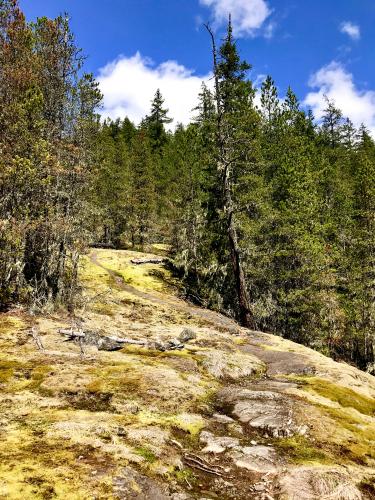
Went up there today and it was really nice. Just a little bit of snow towards the end, otherwise all clear. The waterfalls were beautiful (there was even a rainbow!) and the mountain views were incredible. The trail is pretty well marked for the most part. A quick note on what might be a confusing spot - after you get through the second-generation growth area (after the 2nd waterfall view), you reach a fork in the trail. If you go to the left (heading uphill), you will reach the logging road pretty quickly. If you go to the right, you'll continue on the trail for about another half hour to the boulder field. Head out there and enjoy :)
Posted: April 26, 2014 12:23:42 AM PST
Brock from Lower mainland writes:
Loved this hike, like everyone else is saying: lots of terrain changes, lots of scrambling and climbing, great view points along the way and saw at least 30 eagles.
I don't have a dog so I can't comment on wether it's dog friendly or not, but it is fairly steep at some points and I would think the dog would at least need some trail experience before tackling this one.
I'd also like to comment on the deaths, the trail itself should by manageable for anyone with a general fitness level. The viewpoints however are where you can get a bit sketchy, with some rocks and stuff to lean over. So for anyone who has read about the deaths and got put off by it, use your head, the trail is fine, just be safe at the look outs :)
Oh, currently the trail is snow free but the logging road down has really hard pack snow/ice for about 2kms. Not a big deal, but worth mentioning.
Posted: January 21, 2014 08:15:31 PM PST
HT from Vancouver writes:
I did this hike a few weekends ago and it was great!
I will admit that I am afraid of heights and did find some sections of the climbing scary. I tried not to look down in certain places as it felt as though I was on the edge of a sheer cliff (not sure if that was actually true as I was trying not to look). It was generally manageable, though, and there were only a few short sections that felt frightening. My friend who is not afraid of heights was unphased however.
Overall, I would say the hike was more fun than most due to the varied terrain and different viewpoints. It was also pretty quiet, we didn't see any other hikers on the trail the entire time!
Did the hike in 3.5 hours, but we didn't take a lunch break since we missed one of the viewpoints.
Tip: the trail was a bit tricky to find, but I suggest following the instructions on the website, particularly the advice re: re-setting your odometer to 0 at the specified juncture. That was very helpful!
Posted: August 19, 2013 04:21:09 PM PST
lauribear from North Vancouver writes:
We did this hike last weekend and it was excellent! It's a fun and technical trail with 4 viewpoints of the falls and lots of stunning mountain vistas. The terrain is varied, which keeps things interesting.
I had resisted this hike for a long time because of all the warnings in the trail reports. It's not too bad, but I would not recommend doing this hike on a rainy day or when the ground is slick from long periods of rain. I also would definitely not take a dog on this hike, on or off leash. There are several steep scrambles where you would have to actually lift and pass the dog to another person, if you could even reach that high.
This trail is a bit overgrown in places, I'm sure because it's not frequented often. We only saw one other couple the entire time and this was on a gorgeous sunny Sunday in the summer. Keep your eyes on the pink tape tied to trees and branches. We got quite derailed at one point and the only way we got back to the trail was because we saw the other couple off in the distance. There is no cell service here, so be sure to tell someone where you are going and keep you eyes on the trail markers.
When we reached the logging road, we went left. From there it was a 5.5 km walk back to the car, then stopped in at Alice Lake for a dip. This is a great hike and a wonderful way to spend the day!
Posted: July 31, 2013 11:07:46 AM PST
sarahz from Chilliwack, BC writes:
Did this hike last weekend (July.6/13). Great hike...a better version of the Chief. There is a lot of fun rope climbs, a lot of really nice view points, and did not see a soul all day even though there were a lot of parked cars in the area. Round trip took about three and a half hours; this time includes a lot of photo breaks and one half hour snack break.
Highly recommend giving this trail a go!
Posted: July 11, 2013 05:40:29 PM PST
Brian from Vancouver writes:
I did this hike with a friend on June 22 2013.
Before doing this hike, the only hikes I had done (in BC) were the Grouse Grind, Quarry Rock and Peaks 2 and 3 of the Chief.
My friend and I don't like overpopulated and commercialized hiking trails so we decided to try this one out.
Locating this trail was an adventure in itself. You have to drive over an unpaved road for a while until you pass by an abandoned warehouse and a bc hydro powerstation.
Once past the hydro station, you'll find a small bridge. Park before the bridge and walk over it to find the trail on your right. It was kind of hard to spot as it's nestled in a hallway of trees.
The hike itself isn't too bad. The first section is similar to the chief/grind but with plants surrounding you.
The fun part begins when you reach a section where the only way to go is up.
You get to use your hands and legs as well as the ropes/chains that have been attached to the rock face to climb up parts of this trail. It was pretty fun.
Two of the viewpoints a little ways up are very similar to quarry rock. Big rock face overlooking a backdrop of evergreens and water. Good place to eat a snack and take pictures.
Further down the trail another view is of the waterfall. Can't really get super close to it, but it was nice to see.
The main page of this website warns about dying on this trail. I would say that you would have to be pretty dumb to die on this trail. As long as you watch your step when you are climbing up some of the rock faces and don't go too close to the edges when looking over the sides of the canyon then you will be fine.
The climbing sections are not very difficult either, you won't be climbing for more than 10~20 seconds at a time.
I would be more worried about doing this hike if it was rainy though. If it was rainy, i would imagine it being quite dangerous.
Near the end of trail, there is a fork in the road where one trail leads north and the other road leads east.
The East road has a tree marker which is covered in a shitload of pink ribbon and cloth. If you follow this path, it is a dirt path that eventually leads out of the forest and into a gravel road which is a logging road. This is the end of the trail. You walk down this logging road and it'll lead you back to your car.
My friend and I thought that we had taken the wrong path when we came out here, so we re-traced our steps above until we got back to the fork in the road with the north and east markings and decided to give the north path a try since there were some markings on trees that lead north.
The north path we found was a bit more adventurous. The trail wasn't clearly marked here but you could definitely tell that people had used it in the past because there are some pink ribbons on bushes or tied to hard-to-spot branches along the way. Path was kind of narrow and bushy here, recommend you put on long pants.
The north path actually leads to a hidden lake. It's not much of a view or anything, just something to see on this trail.
However, we were surrounded by land that was much higher than us so we decided to walk east (from the lake) and up the side of these rocks that were close to us to see if we could get to the logging road from here. We kept walking up and over rocks and over some bush and fallen trees and finally spotted the road from where we were.
There is no marked path at this point, we were just feeling a bit adventurous which is why we decided to do this.
We were lucky that this "north" path did end up leading to the same spot as
the "east" path did at the fork in the road.
The north path is a much, much faster way to get to the end of this hike, but it involves some navigation through fallen trees, rocks and bush.
Walk down the logging road when you finish this hike, there are a couple of nice views.
Overall, it was an interesting hike. Fun, not too difficult and not too many flies when compared to GG or chief.
Not sure if i'll do it again though, you won't have reception on your phone when you're out here so keep that in mind if you do it alone.
When we got back to our car, we saw about 8 cars parked around us. Ran into a few ppl along the way too. Not very busy at all, but busy enough that you won't feel alone.
This past week my friend and I did elk mountain, I'll write up a review for that later.
Posted: July 2, 2013 08:31:19 PM PST
Tim from Port Moody writes:
Anybody know where the logging road that you come out on ends up? We saw lots of vehicles going up but not coming back down.
Posted: June 30, 2013 09:16:26 PM PST
Sarah and John B from Vancouver writes:
We did this hike today and really enjoyed it. We drove by the trailhead the first time and then managed to back track once we realized many people were starting at the 'end of the loop' where the logging road meets SRV road.
The entrance had a whole bunch of flags and a small, washed out sign. The entrance is about 100 ft past the bridge on the right.
When we arrived at 9:30am there was no one there and when we left there was at least 12 cars!
We really enjoyed starting the hike with the spectacular falls viewpoints and couldn't imagine trying to do down the steep bits the other way.
Even though the trail markers were severely lacking in some areas we found our way without getting lost. We only saw 1 other group the whole time which was surprising!
Overall, great hike, took about 2.5 hours round trip.
Posted: June 2, 2013 06:49:55 PM PST
Katie P from Vancouver writes:
This was a great trail, though we got lost at the section which opens up to logging. There were flags everywhere! Remember to keep right and head up the valley, we ended going onto the road to soon after following the wrong trail. It was still very pretty and the view from the road is great, even though it does go on for a while. I would do this again, only saw about 10 people.
Posted: May 6, 2013 10:03:04 AM PST
Cody from Vancouver writes:
Hiked this today and the trail is definitely showing some age. Challenging to find markers at times and got lost after one stupid turn, but easily made our way back to the real trail. Keep your eyes on those markers. Near the end where it appears to open up to the skies is a long-ago logged area the markers get quite confusing. We ended up going right, over a creek, and continued following markers until the logging road.
The logging road was covered in snow for the first 15 minutes of walking, but is easily passable with running/hiking shoes, as it is very firm.
Posted: March 31, 2013 09:13:12 PM PST
Tony from Napa writes:
Easy to find, stunning views, not too difficult if you're in decent shape. How steep is the canyon? There are places you can crawl out to the edge, look over the cliff, and not see the stream several hundred below you!
We did this in late June 2012 and loved it. The only "problem" we encountered was the hike up to the logging road...the trail splits several times and they're all flagged...so it's your guess.
At the first major split "left" turns immediately into a very rugged recently created boulder field/landslide that didn't look passable, so we continued "right" up the canyon. A mile or so up the canyon the trail splits again, both trails were well marked and flagged..."left" went directly up the hill and "straight" took you further up the canyon. We went straight but I think if you go up here you can probably shorten the hike. The trail we took was flagged for a while but gradually got narrower and less well marked. We eventually reached a boulder field (follow the stacks of small stones to navigate through) that dumped us out on the logging road. From there you turned left (uphill for a while) in order to get back down.
Posted: July 6, 2012 09:44:24 AM PST
Deb from White Rock writes:
Hey "Me from Burnaby",
The road is paved for most of it, but as you near the trail it turns to gravel...at least it was that way last year..? :) Even with the gravel, though, it is accessible with a passenger car. Happy hiking!
Posted: May 29, 2012 05:43:54 PM PST
Me from Burnaby writes:
Would someone please confirm if the 23.5 km of road to the trail head is paved or gravel? Thanks very much.
Posted: May 29, 2012 12:15:51 AM PST
Sam from Surrey writes:
Did this Hike on May 26th 2012. The trail is in great condition although it isn't the most clearly marked at the entry but along the way the path is well worn and there are tape markers, so you can figure it out. We walked down the logging road which offered beautiful scenic views but it was hard on the knees and little annoying with the loose rocks. Overall I would say this was a fantastic hike, that offered amazing views along the way and less foot traffic than the Chief.
Posted: May 28, 2012 04:50:27 AM PST
Rachael from Vancouver writes:
Hiked this trail on April 29 and found it very poorly marked. The trailhead sign is completely washed off. We took a chance and turned in at the white piece of plastic on a tree and lucked out. The hike was lovely but there were several times that the path was not clear. Very few trail markers existed. Strangely enough, the best marked part of the hike was in a direction away from the 'rock field' that you are meant to traverse. There's also recreational gun shooting somewhere in the area. At first we thought it was rocks banging in the water, but a local confirmed the ongoing noises were indeed gunshots.
Definitely a beautiful hike, but advisable to carry directions and give yourself lots of time in case you get turned around.
Posted: May 6, 2012 07:12:55 PM PST
Catherine from Vancouver writes:
Enjoyed this immensely today, 28th April 2012. Really easy to follow,there were 5 of us and a dog. This panic on threads regarding dogs is extreme and over the top,its absolutely fine. We helped ours up two small rocks sections and he just ran up the others. Nice hike up with some climbing here and there,very well set up ropes to help. Amazing views of Tantalus and Squamish valley,some of the best views around. Took us 4 hours with two fifteen minute breaks for snacks.
Don't come down the same way,defo do the loop along the forest roads,nice views. We all found it easier than Grouse and the Chief....was fab!
Posted: April 28, 2012 07:11:25 PM PST
Scotty McW from Prince George writes:
Rocked this hike today, my first "Solo September" hike of the month.
Beautiful scenery, challenging sections, lots of mountain, water and valley views.
Enjoy!
Posted: September 10, 2011 05:12:54 PM PST
Diane from Maple Ridge writes:
Great hike today.
Only one thing we left a set of walking poles by our car (Sept 3 around 4:00pm)and then drove away forgetting them. If anyone does find them and would love to contact us to see if we can pick them up I would love that. Can be contacted by email address [email protected]
Posted: September 3, 2011 07:13:33 PM PST
Lisa from Vancouver writes:
This is by far my favourite hike. I love how technical it is by having to use ropes periodically on the hike to help yourself up. I also love the multiple view points, different "terrains" (ie: out on the rock edge, through the forest, over a boulder field, etc), and that it was a loop rather than a straight return.
Does anyone know of any other hikes like this in the Greater Vancouver area that uses these types of ropes/chains and have similar attributes? I know the Chief does, and I LOVE the last quarter of that hike (2nd peak), but I cant find any others similar to the technicality.
Any ideas??
Posted: July 30, 2011 05:25:48 PM PST
Jen from Vancouver, BC writes:
I did this hike on Saturday and it was AMAZING! I'm not an avid hiker, and I don't like heights, so I was a little nervous about this one, but, I loved it! Lots of fun chains and ropes to help you scramble up and over some rougher/ steeper terrain, amazing views of the waterfall, and viewpoints that allowed safe distance from steep edges. The only downfall is the 5km trek down the logging road at the end. Would definitely do this one again!
Posted: July 12, 2011 09:49:30 AM PST
chiggins from live in squamish. From ontario writes:
Good hike. We brought 2 dogs with us, but they were very nimble and young. Had to pick the big dog up at one point to help him up the rockface.
It's a good long hike. Not for those out of shape. You may come to a point where you are questioning where you are and if you are on the right path. Just keep going. Keep in mind the falls are about a quarter of hike and only halfway up the mountain at best.
Took us 4-5 hrs. Best part was soaking our feet in the river across the road when you get back to the main road.
ENJOY
Posted: July 10, 2011 08:59:56 PM PST
Matt from London writes:
Did this hike today.
The sign at the start of the trail is pretty weathered and hardly readable, but it's the first path on the right after the bridge so hard to miss. The length of trail (and amount of climb) in the forest after the ridge is somewhat greater than you might imagine from reading the trail description, but the path was pretty easy to follow -- and easier going than the ropes and chains at the beginning!
When you get to the gravel road, the log bench mentioned in the description is no longer there. The views of the valley from the road are great, and to some extent make up for the fact that the trees and cliff edge on the earlier part of the hike mean you never get a really great view of the falls themselves.
That said, the road part of the hike is a good hour and a half at the end, and with all the loose gravel not as much of a stroll as you might hope. We were glad to have poles for some of the steeper bits.
Posted: July 6, 2011 11:01:30 PM PST
Chris from Whistler writes:
This hike is fun for the people that like a little more excitement in their hikes. There are often chain and ropes to get help you up the very steep sections. I did it with two other guys and we thought it was great but maybe not for people that are afraid of heights.
The views were great and the falls themselves are amazing. I found the only downfall to this hike is the fire road you take going down back to the trailhead. It was 5km of constant downhill on a road with very angular rocks. We had to stop cause it was killing our feet.
Posted: June 19, 2011 05:01:22 PM PST
Sonia from Delta writes:
This hike has several stunning views of the Tantalus Range as well as all the different views of the falls. Definitely take the short side trail to view the falls from the back side. You will enjoy the VERY cool breeze if it's a hot day (Squamish hit a temperature record of 36.7 degrees the day my husband and I hiked this trail). When scrambling over the boulder field at the top of the hike be sure to follow the little cairns that someone has built. It is the most direct route to the gravel road.
The only downside to this hike was the insects. LOTS of hungry mosquitoes in the forest near the top so bring your bug spray. Also, I got stung by a wasp three times at the very beginning of the trail and one more time near the top. Wasps were also a problem when I did this hike over 12 years ago. Oh well, it is still a fantastic hike.
Posted: August 15, 2010 04:52:17 PM PST
Brian from Delta writes:
This is probably one of the best and most underated hikes.. a definite Gem. Did it on Mar 8, 2010 and there were only two cars. We had a great time. The gravel road for 2km is a bit dicey.
Posted: May 10, 2010 03:23:06 AM PST
Michelle from Vanouver writes:
My boyfriend and I had a great time on this hike. It only took us 1.5 hours to get there from Vancouver. It was a perfect day hike, we left Vancouver around 9:30 am and were home around dinner time (including stops in Squamish). It was rigorous, scenic and challenging, but not TOO challenging. The views were great. Definitely stop and enjoy the view of Tantalus Ridge once you get over the falls.
Posted: May 8, 2010 07:49:23 PM PST
Linda from Burnaby writes:
This hike has it all: nice falls, fantastic views, climbing & scrambling, and walking through a beautiful forest.
Posted: May 26, 2008 03:20:43 PM PST
Have you hiked High Falls Creek? Share your experience with us:
Comments that gratuitously attack or demean individuals or organizations are not acceptable. We reserve the right to remove comments or any other content we deem unacceptable in our sole discretion, including removing user names and profile pictures. For our full website terms and conditions including our legal guidelines for user postings and comments on www.vancouvertrails.com, please see our Terms of Use and Privacy Policy.

JSR from Vancouver writes:
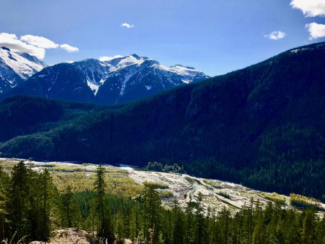
Nice hike, many great viewpoints. The long version of the trail is moderately difficult (maybe a harder moderate trail). It is steep for the most part, especially to the falls and for a kilometre or so after. There are short class 2-3 scrambles and some chains/ropes to help with some short exposed climbs. You finish by crossing a boulder field (200-300 meters) after which you pop out onto a forest road and walk back about 6 k down to the trailhead. The views on this descent are fabulous. We saw no berries in September, and zero evidence of bears (predictably) - and no bugs. I would do this hike again. It’s a decent challenge, and a good day hike with all the elements of coast BC hiking. You have to pay attention to the trail marking.
Posted: September 12, 2023 11:25:50 AM PST