- Difficulty Difficult
- Time 8.5 hours
- One-Way 16km
- Elevation Gain 1320 meters
- Season July - September
- Camping No
- From Vancouver 40 minutes
- Public Transit Yes
- Dog Friendly No
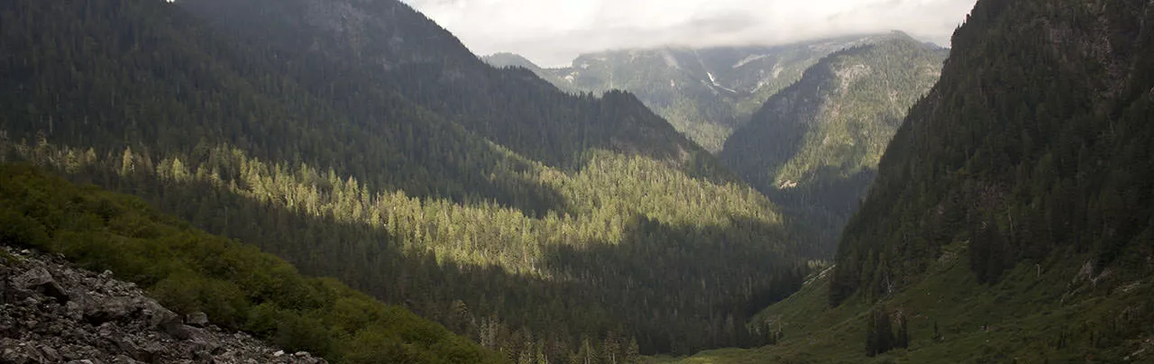
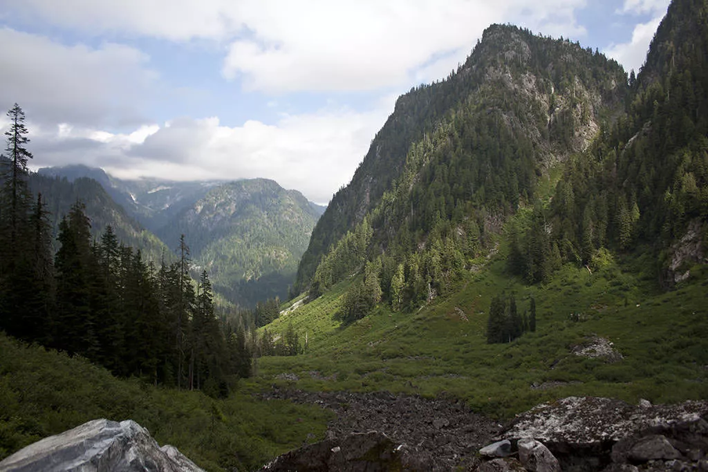
The Hanes Valley Trail is a very difficult hiking route that starts from the Lynn Creek crossing in Lynn Headwaters Regional Park and ends on top of Grouse Mountain. What makes this backcountry route so difficult is the extremely steep boulder field that hikers must scramble up, using their hands and feet. The views of the valley are quite scenic though and the trail also passes several other points of interest, including Norvan Falls and viewpoints of Crown and Goat Mountains.
A few things to know before you hike the Hanes Valley Trail, one is that the route starts at one end of North Vancouver and ends at a completely different location. That means trip planning, prior to starting the hike, should be done to make sure proper transportation has been arranged at the end of the hike. Secondly, this hike is meant for experienced hikers and those who are in very good physical condition. This is one of the areas where North Shore Rescue spends too much time rescuing ill-prepared hikers, so make sure you are up for the long trek and steep climb through the backcountry terrain. Thirdly, make sure to hike this trail when it's free of snow as hiking up the boulder field is extremely dangerous without proper equipment when there is snow. Even in the summer months, snow can linger to well into July. Lastly, remember to bring money ($10 as of 2013) to pay for the Grouse Mountain Skyride.
The trail starts from the parking lot at the end of Lynn Valley Road in Lynn Headwaters Regional Park. Follow the trail across the bridge to a large signboard with a map of the area. Since this is a backcountry hike, it's a good idea to register at the board by dropping one part of the form into the dropbox and taking the small attached slip of paper with you so you can phone the number later to let Metro Vancouver know you have completed the trail safely. Once you've done this, go left and following the wide trail next to Lynn Creek. It's a good idea to hike the first section at a fairly moderate pace as it's relatively easy and important to make good time at the beginning.
The wide trail continues for sometime as you pass a junction where the Lynn Loop trail joins this route. Continue along the wooden bridge as the trail begins to narrow and goes through a forest of small trees. After hiking more than an hour, the trail reaches a clearing known as the 3rd Debris Chute. The mountain viewed on the left is Mount Fromme. The trail continues up the debris chute at a junction, where you will go left towards Norvan Falls.
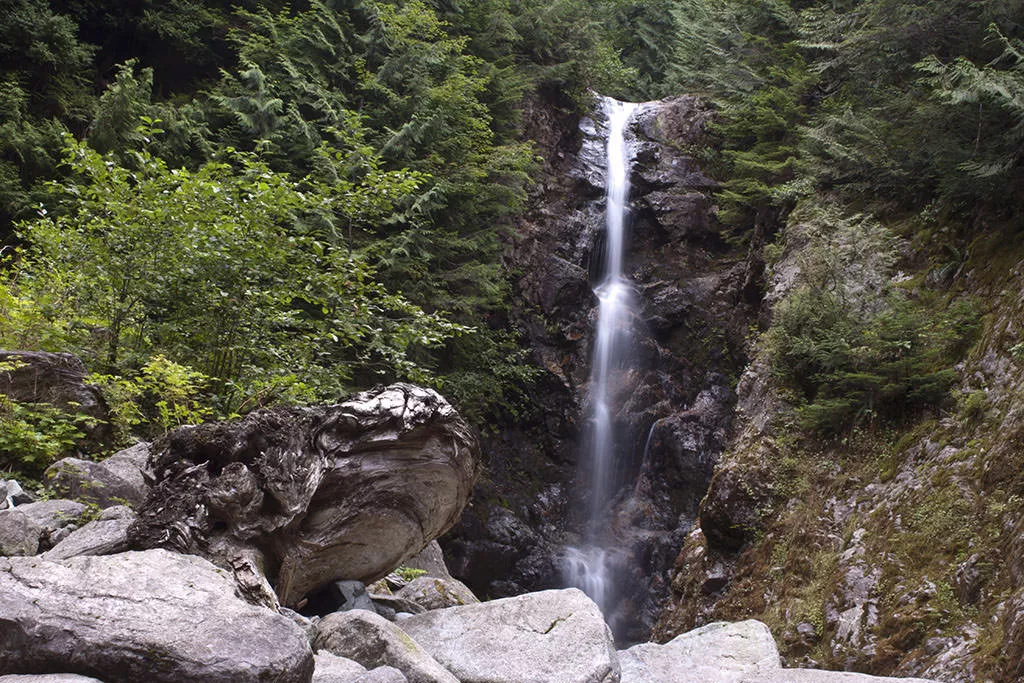
After pass the 3rd Debris Chute, the trail becomes noticeably quieter and free of most dog-walkers. The path also becomes narrower and much more rocky and rugged as you find yourself dropping down into creek beds and hiking back out the other side. Continue hiking at a decent page as the trail passes through the forest and eventually reaches a junction for Coliseum Mountain. Pass the junction and a few steps further, another junction for Norvan Falls, where a short trail to your right takes you up for a scenic, worthwhile view of the falls.
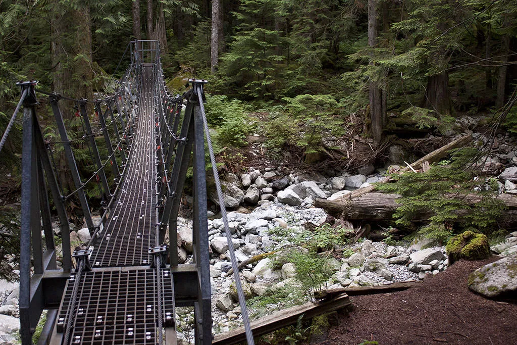
After viewing the waterfall, walk back to the main trail and cross the metal suspension bridge. This is the point that you are officially entering the backcountry and the trails beyond this point are not hiked as often as the previous trails. Therefore, it's important to watch for trail markers on trees and rocks and not stray too far without seeing one as it's easy to lose the trail and become lost.
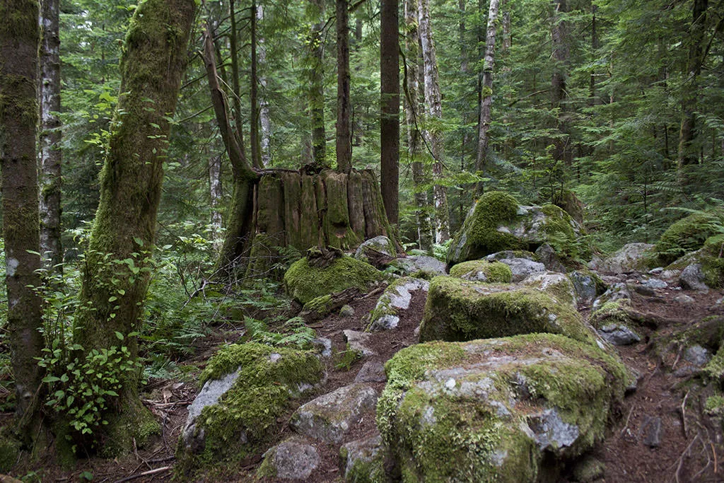
Follow the rugged trail as it makes its way through the second generation growth forest. The route continues its gradual uphill climb but nothing too strenuous up until now. Eventually, you reach another junction marked by a sign with map of the area. Going right takes you to Lynn Lake, however you want to go left and down the steep hill to follow the Hanes Valley route. After hiking down the steep hill, you reach Upper Lynn Creek. There is some rocks and trees that have built up that are used as a crossing but be very careful as it's easy to lose your footing on the slippery rocks and you're a long ways into your hike.
After crossing the creek, continue following the trail and make sure to pay attention for trail markers on trees. The vegetation through this section of trail is a bit more open and sometimes the trail is not obvious but the markers on trees are in good condition and easy to follow when you look for them. There are a few steeper sections in this part of the trail, however nothing too bad compared to what lies ahead. Eventually, you will cross another creek bed that's dry in the later summer months. Look for the flagging on the other side and continue your hike along the trail.
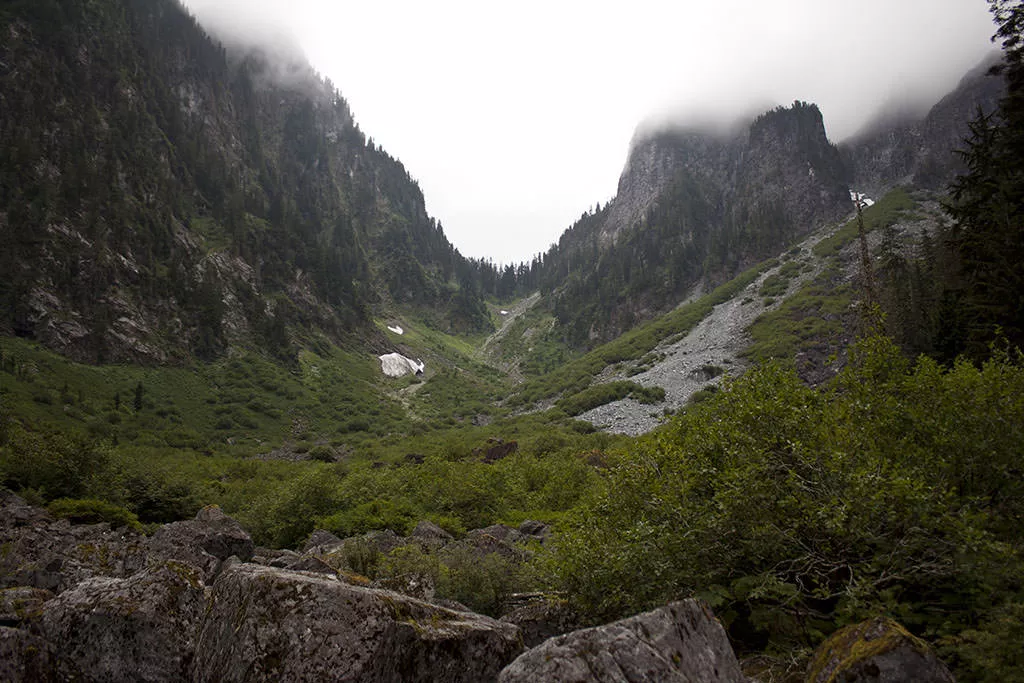
The trail starts to offer the occasional glimpse of the surrounding mountains. After crossing a small creek, the trail reaches a clearing, next to a storage box and a helicopter pad on the left, with a view of the boulder field in Hanes Valley. It's an incredible, breathtaking view look up the rocks towards the top and that's exactly where you will be hiking. The distance to the top of the boulder field is about 1.5km and the elevation gain is more than 500 meters! The first section beyond the helicopter pad continues along a trail, up a very steep section. Then the trail ends and you are among he rocks. The route is generally well marked with flagging tape, so plan your footsteps over the rocks so you go from one marking to the next.
The rocks seem like they go on forever and, while it seemed like you were making good time, this section of the trail takes most people over an hour. Don't forget to stop and look back down as the views back down the Hanes Valley are incredible. Eventually, you reach the end of the boulder field and enter amongst some trees, however this trail continues at a very steep rate. A couple of switch backs later, the trail begins to level and you reach the junction with the Crown Mountain trail.
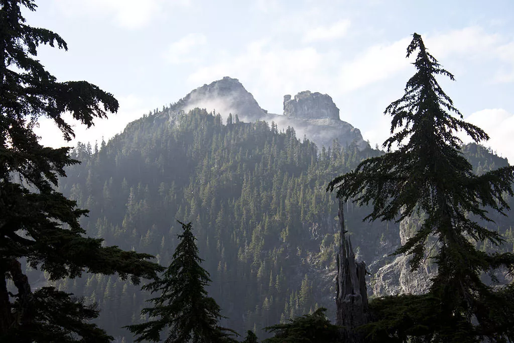
At the Crown Mountain, go left towards the Goat Mountain trail and eventually Grouse Mountain. The next section starts out quite easy as you cross a small, open rock slide area. However, things change fast as the uphill section begins. The steep trail is very rough and often muddy as little sunlight reaches this area of trail that is hidden behind several mountains and deep amongst the vegetation. Continue your uphill climb until you reach a series of chains that are bolted into the rocks. Use these chains to help you get up the steep, slippery rocks. The trail continues uphill until it finally reaches a rocky bluff with a view of Crown Mountain on a clear day.
A few steps beyond this viewpoint, the trail meets with the Goat Mountain Trail. Go right up a small hill and from this point forward, the hike should be much easier from the sections you have completed. The trail passes a couple of junctions, including Little Goat Mountain and Dam Mountain, but keeping following the trail markings towards Grouse Mountain. The trail eventually reaches a Zipline platform, a popular tourist attraction in the summer. Go right and follow the trail down hill below the Zipline platform. Not much further and the trail widens and turns into an old service road. Follow this road as you can now see the Grouse Mountain chalet in view. Pass the grizzly bear enclosure and follow the paved routes towards the Skyride.
How to get to Hanes Valley Trail
Estimated Driving Time from Vancouver
40 minutes
The Hanes Valley Trail begins at the top of Lynn Valley Road, in North Vancouver, in Lynn Headwaters Regional Park. It's important to note that the trail ends at Grouse Mountain, where you take the Skyride back down to the base of the mountain. The starting and end points are a long distance apart, so make prior arrangements so you are not stranded at the end of the day.
To get to Lynn Headwaters Regional Park, drive east through Vancouver to Highway #1 and enter the highway heading westbound. Cross the Iron Workers Memorial Bridge (2nd Narrows). Just after crossing an orange bridge, take Exit #21 to Mountain Highway. At the stop sign at the top of the hill, turn right onto Mountain Highway and following it as it winds its way uphill. Continue following Mountain Highway until a major insertion with Lynn Valley Road. Turn right at the lights onto Lynn Valley Road and follow it until it reaches a 4-way stop sign at Dempsey Road. Go straight through the intersection and pass through the open yellow gates, taking note of the time the gates close. This is important as you will want to make sure you are back at your car before the gates close. Follow the narrow road all the way to the end and park in the last parking lot. If there is no parking, there are several overflow parking lots a short distance back.
View a map of Driving directions to Hanes Valley Trail.
Transit Access to Hanes Valley Trail
The Hanes Valley Trail starts in Lynn Headwaters and ends on top of Grouse Mountain on the other side of North Vancouver. This is a great hike to take transit as both areas are serviced by public transit from Lonsdale Quay.
NOTE: If you leave your car in the parking lot of Lynn Headwaters and plan to take the bus from Grouse Mountain to your car, make sure you leave lots of time as the gates to Lynn Headwaters Park are closed at night. The times vary, depending on the time of year, so check the time before you enter the park. If you don't think you will make it back in time, don't take a chance, leave your car parked outside the gates.
To get to the start of the Hanes Valley trail at Lynn Headwaters Regional Park, take Bus #228 Lynn Valley from Lonsdale Quay. You will need to get off the bus at the end of the route at Underwood Avenue and Dempsey Road. After getting off the bus, walk back down to Dempsey and go left onto Dempsey. At the stop sign, go left onto Lynn Valley Road and walk along the road into the park to where you start the trail at the final parking lot.
From Grouse Mountain, bus #236 goes from Grouse Mountain to Lonsdale Quay. You can transfer to the Sea Bus at Lonsdale Quay to take you across the water to downtown Vancouver. If you are attempting to return to Lynn Headwaters Regional Park to pickup your car, you will have to take the #236 bus to the Lonsdale area where you will be able to transfer to the #228 bus. It's probably easiest (and longest) to go right to Lonsdale Quay but ask the bus driver if there are any points of transfer along the way. There is no easy route transferring to buses across North Vancouver.
One other note about buses, Grouse Mountain runs a free shuttle service during the summer that makes trips between Grouse Mountain and Canada Place. Check with Grouse Mountain as to whether this shuttle service is in operation and what the pickup times are.

Although we try to keep information as current as possible, www.vancouvertrails.com makes no warranty or representation as to the availability, quality, fitness for purpose, conditions or accuracy of the information provided with respect to this trail or trails. The information provided herein is further subject to our Terms of Use.
Comments
Add Comment View All Comments