View Two Canyon Loop Description | Add Comment
Paul van Aggelen from Burnaby writes:
Went there today, hiked down the Seymour Canyon part (that was nice), but heard that the Lynn Canyon trail was closed. There was no notice anywhere, rather disappointing. So, for us, I guess it was only really a 1.5 Canyon Loop. ;-)
Posted: March 11, 2020 04:33:34 PM PST
Lisa from Vancouver writes:
The landscape is beautiful and the hike great exercise. Really all you could ask for. However, there are absolutely zero trail markers for this specific Loop. I followed the directions from this site exactly as written and got lost twice. Not because I can't follow directions but the ones listed took me completely the wrong direction. The point where it says to cross the road, please don't. You will end up on a gorgeous trail that will take you four km out of your way.
Would I recommend this hike; yes. However go with someone who actually knows the area well and has done this hike before to save yourself the frustration of incorrect directions.
Posted: July 28, 2019 05:31:38 PM PST
Deborah N from Vancouver writes:
Loved this trail!
We went on a sunny Sunday afternoon at the end of May 2019.
There was lots to keep my 12-year-old son interested - including old tunnel you can walk through, some beautiful bridges and a couple of nice spots to get down to the river and get your feet wet.
Got quite busy around the Lynn Canyon Suspension Bridge, but otherwise just perfect!
Highly recommend.
Posted: May 28, 2019 06:15:11 PM PST
Roger from Vancouver writes:
Dec 27, 2018 - The Two Canyon Trail is now fully walkable again. Twin Bridge is open, and the bridge/stair at the southern Pipe bridge which has been closed until recently is now reopened with new metal staircase on BP Trail. The new Twin Bridge is a large, solid metal suspension bridge, about 6 ft wide. Fishermen’s Trail to the bridge is a new wide gravel road.
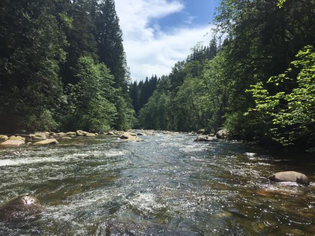
Both the rivers are enjoyable, trail is close to them, with some really good waterfalls. Trail condition and signage very good. First half is all gravel roads, second half mix of wood stairs/boardwalks and forest trail. Busy around Lynn Canyon Centre. Nice uphill workout from Pipe bridge to top of ridge.
Posted: December 27, 2018 04:10:40 PM PST
Carlie from Vancouver writes:
Yes the bridge has been removed and unless you have a device (like a boat) to get you across the river you can not cross.. it's even been gated off.
We also ended up doing fishermans loop trail but didn't find it very interesting. It's the same scenery along the river on a groomed trail then we returned on the paved bike route (not great walking on concrete after 7km for another flat 7km) The mossy dark forest was cool but not worth the 14km return hike in my opinion.
Posted: May 14, 2016 01:38:29 PM PST
Cristi S. from North Vancouver writes:
The bridge has been actually removed (you should update your info).
However, we've just discovered the interesting short loop on Homestead Trail, Fisherman's Trail and Twin Bridges Trail, coming from the Lynn Canyon Suspension Bridge area.
We just completed all this in less than two hours. That's also an easy hike.
Posted: July 17, 2015 04:01:57 PM PST
Kat B from Vancouver writes:
Hiked this on the weekend. Was a pretty rainy day but luckily the trails had a lot of walkways and stairs. Only had to cross a few really muddy patches. suspension bridge was really cool. We got lost a few times so we ended up sticking to the baden-powell trail for the majority of the time.
Posted: November 12, 2014 12:56:02 PM PST
JohnS from Langley writes:
This was incredible, hiking through the think canopy was awesome with a light rain falling periodically; FEW Tourists and School’s in! Most of this route is gravel which also makes it a great rainy day hike. Our modification included a forced detour and crossing the bridge at Twin Falls and returning via the Suspension Bridge; which stretched it out to just over 11 KM. For maximum enjoyment I would say don’t do this on a weekend – Sunday was gridlock ...unpleasant.
Two Canyons is unofficial because even the Park’s staff can’t tell you anything other than that they’ve heard the name used; in actuality it’s (for our route) seven trails. Our route is modified as the Fisherman’s’ Trail is CLOSED to the Twin Bridges on Weekdays, and next to the large Closed sign there was also No Dogs sign – so even if it was open we would have most likely diverted with mutt in tow. I’ve gone a little overboard with the directions as I’ve had trouble following ones I’ve read previously.
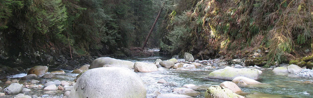
The easiest way to start this route is from Lynn Headwaters Park. You will notice the Pipeline Bridge to your right (just off Rice Rd.) as you enter the park – if on foot start here. If you drive in, all parking lots have access to the Varley Trail which will exit nearby the bridge – just veer right on the road (unlike we did) and you’ll see it. This trail becomes the Seymour Valley Trail Way and will take you to the Rice Lake Gate House. Continue straight on the paved path and you’ll be on the Twin Bridges Trail. This (gravel road) trail eventually takes you to the Fisherman’s Trail Junction – turn left before the blue bridge. (There is a great picnic spot / swimming hole just over the bridge). Follow the trail to the junction (“closed” sign) and turn left onto the Homestead Trail. This will take you back to the Gate House where you veer left onto the Baden Powell Trail. This will loop down over the foot bridge at Twin Falls and take you back up to the Suspension Bridge. Once over the bridge a left turn will take you on to the Suspension Bridge Trail which if you follow the river will lead you back to the Pipeline Bridge where you can join the Varley trail to your car or head out to the bus stop.
The route has some long, steep (7%) grades and lots of stairs.
Posted: September 23, 2014 10:11:00 AM PST
kate murray from Vancouver writes:
looking forward to hiking this trail tomorrow... but just wanted to say it stinks to see pro-pipeline ads on the site!
Posted: August 15, 2014 12:59:17 PM PST
Fri from Vancouver writes:
I ran this trail on Sep 10. Beautiful day and lots of walkers out.
If it's your first time I recommend you take directions with you - both for road access (see Kathleen in Vancouver's instructions) and the actual hike route. I didn't have either with me, and while there were many signs along the way this area was a mishmash of many different trails and my memory failed me several times... Resulting in a 11km run instead of 8 and missing the suspension bridge.
As someone else pointed out, this trail should be classified "Easy". There was only about 700m at the bottom of the loop that really stopped me from running, everything else was a breeze.
A very well-maintained trail.
Posted: September 12, 2013 10:52:34 PM PST
Levi from Copenhagen writes:
We hiked the Two Canyon Loop in Sept. 2013.
It was a bit difficult to find the beginning of the trail - there's a largish water treatment plant between the last described landmark and the ranger station/parking lot, which made us think we'd missed the entrance somewhere.
So, from the cemetery and yellow gate, continue 1 or 2km through the speedbumps, another 0.5km past the water treatment plant, and you'll reach a large park area for Rice Lake and Lower Seymour Conservation Reserve, with a parking lot 100m further on. The trail begins at the northeast corner of the parking lot, away from most of the other trails.
I second the recommendation to bring these instructions along, as this is an unmarked mashup of several different official trails.
The loop begins with a steepish downhill that quickly becomes a fairly dull stroll along a wide gravel path for maybe the first third of the hike. After crossing the Seymour River, it quickly becomes more interesting with a switchbacked uphill section, and most of the loop from here to the end is more fun and challenging.
We took 3.5 hours with plenty of breaks and lollygagging.
Posted: September 2, 2013 07:53:31 PM PST
Molly from Sydney writes:
Lovely trail, nearly deserted on a warm summer afternoon apart from some swimmers on the Seymour River and then the crowds at the Lynn Canyon suspension bridge (worth avoiding, I thought, for that reason). I greatly appreciated Kathleen's extra instructions - they made the beginning of my stroll much nicer. And the Seymour River is warm and delightful to swim in - I recommend the swimming holes near the tunnel and the bridge. I'm going back as soon as I can.
Posted: July 31, 2013 09:30:49 PM PST
Jray42005 from Vancouver writes:
Finished this trail yesterday with a few friends.
Make sure if you have never done this trail before that you have the trail directions handy because there are not many signs and there are quite a few junctions leading to other trails.
If i were to rate this trail I would say it was Easy rather than Intermediate. The first half of the hike was kind of boring. You pretty much walk a level trail which was not much of a challenge. But do watch out for the tunnel on the right side of the mountain. It was dark and creepy and reminded me of how horror movies start. And I almost missed it.
The hike got interesting when we hit the steep stairs and uphill swtichbacks. now these are the kind of hikes I like.
Once we crossed the suspension bridge and reached the Ecology Centre, we thought we were finished and celebrated lunch. After realizing that we still have ten minutes more to walk UPHILL! So make sure you do not eat a large lunch.
The description says after you cross the suspension bridge again after the Ecology Centre to turn left. Nope next left.
I give this hike 7/10
Posted: June 20, 2013 05:45:35 PM PST
Kathleen from Vancouver writes:
I hiked this loop yesterday with a friend. We used public transportation and it took us a while to locate the trail head. We walked down the wrong path twice and had to turn back to locate the trail.
Here are some more detailed directions, in case they are useful to someone else taking transit. You can take the 210 bus from downtown Vancouver or the 228 bus from Lonsdale Quay. If you take 210, get off at the last stop, Evelyn and Underwood. Backtrack one block along Underwood to Dempsey. Turn left on Dempsey and walk a block or so to the end of the road, where it intersects with Lynn Valley Rd. You'll see the store/cafe to your right. If you take 228, the last stop on the route is right here, at Dempsey and Lynn Valley Rd.
From Dempsey Rd and Lynn Valley Rd, walk north along Lynn Valley Rd until you see Rice Lake Rd to the right (not a sharp right). Take Rice Lake Rd until you see a wooden bridge to your right. Cross the bridge and turn left. Walk until the path opens onto an area with a big sign, a water fountain, and a parking lot. Go to the right. As you walk, pass the water fountain to your right and a green roofed building to your left. You'll pass the parking lot on your right. Keep walking right past the parking lot. The path will turn to gravel at the end of the parking lot and you'll pass some outbuildings belonging to the water district. This is where the directions for the hike begin.
The directions are pretty clear, but keep them with you and follow them carefully, as there are several junctions and 'Two Canyon Loop' isn't a route or trail designated on any signs.
This is a great hike to open the season -- mostly easy with a few switchbacks and stairs to warm you up a little! We did it in about 2 hours, closer 2.5 hours if you include the time we spent figuring out how to get from the bus stop to the trail head.
Posted: May 7, 2013 11:41:17 AM PST
Sandie from Vancouver writes:
Driving from Vancouver city to Lillooet took us less than 20 mins. There are two Lillooet roads - Old Lillooet and Lillooet. Be sure the take Lillooet when you're keying in direction on your GPS.
We followed the directions and drove past the cemetery and a long stretch of roads with speed bumps and managed to finally reach the gravel carpark. Do approach the park ranger for a reliable map and route recommendations.
We managed to go around the rice lake, took the Lynn Headwater Connector, did the Varley Trail and finished off with the Suspension Bridge Trail.
All these took us about 3 hours. It was a great route to start for beginners.
Posted: April 15, 2013 12:23:53 PM PST
Alex from Burnaby writes:
Regarding where to get off the bus, "Get off the bus near a corner store and walk a short distance". Hmm, does this mean the cafe/store at Dempsey and Underwood?
Posted: September 30, 2012 10:12:35 AM PST
karen from Vancouver writes:
Once you start the trail, and descend down into the Canyon, it's very scenic and beautiful. Once you get to the bottom, and walk along the river, it's walking on a gravel road all the way until you get to the Pipe line bridge which we found rather boring. It was also really hot today too, so the heat bothered us as we didn't find the trees were sparse along the way, and didn't provid that much shelter as. However, after you cross the pipeline bridge, and get into the Baden Powel trail, you are back into the tall wooded tree area, which is much more interesting and cooler but not for long, as you hit more gravel road after that, and then you are back in the wooded area until the end. Would not recommend this trail on a hot day,as we felt this really slowed us down. Still like Brother's Creek the best!!!
Posted: September 8, 2012 09:05:07 AM PST
Penny from Vancouver writes:
Some friends and I did this hike on a hot August day and it was a good choice for such a hot day, as it wasn't too challenging and the trees provided a lot of shelter from the sun. The first part of the hike is very easy with no elevation gain or difficult terrain. The scenery is picturesque and the route is relatively quiet. The most challenging part of the hike is the steps after the pipe bridge and the following uphill switchbacks but this is quite a short section. The best spot to stop for lunch is after this section when the trail heads down towards Lynn Creek. The rest of the trail is busier as it reaches the suspension bridge. We took a copy of the instructions and found them accurate and easy to follow. This is definitely one of the easier intermediate hikes listed on this site.
Posted: August 19, 2012 11:21:42 PM PST
Jessica from Vancouver writes:
After getting lost several times we finally figured out the trail starts to the right of the parking lot! Unfortunately my boyfriend and I went over to the Lynn Cannon suspension bridge and tried our hardest to find the loop trail (going back and forth and searching everywhere). Just when we were going to call it quits and get into our car and leave I decided to go check out a sign I saw hidden to the right of the parking lot. OH the trail starts here.... We were excited to finally start the hike!
The hike can be tricky to follow so keep your eyes peeled and either your phone available with the correct directions or print them out. We went off trail numerous times.
The tunnel to the right of the trail is really only scenic. We thought it would make us appear somewhere else on the trail.. but it just pops you right back out of the same trail.. You really don't need to go into this tunnel cave if you aren't up for a dark path.
To be honest we barely broke a sweat on this hike. The only reason we even broke sweat was because we decided to run through some of the trail to make sure we were getting our intended work out. There is a couple things they some people may find a little hard to do, but overall just an easy walk hike.
Don't cross it off your list of hikes to do as this is a great scenic one :). Just beware because it can get a little populated as the hike is in the tourist area of twin falls/ Lynn Cannon suspension bridge.
Posted: August 16, 2012 10:34:26 PM PST
Albert from Vancouver writes:
Hiked this trail today with wife and 2 kids (5.5, 8.5). We started from the Lynn Valley Ecology centre and went clockwise. It took us over 3 hrs due to the multiple rest stops for the kids to observe banana slugs, explore the tunnel, side trails to seymour river and Lynn creek, lunch, etc. I figure I could easily shave an hour off our trip if I did it on my own. I would nickname this the "5 Bridge" trail: Lynn suspension, Twin Bridges, Mystery Creek, Pipeline bridge, and finally Twin Falls. The main workout challenges are: stairs going up from 30ft pool towards Rice Lake Gate, the Baden Powell after crossing Pipeline bridge, and the Stairs after Twin Falls.
If you parked at Rice Lake Gate, then I would not cross the Twin Falls bridge, but stay on the suspension bridge trail heading back to Rice Lake. Very enjoyable hike, and great scenery.
If we do this hike again, we may go visit Lizard Lake.
Posted: July 16, 2012 12:33:17 AM PST
Katie from Vancouver writes:
I hiked this trail with my girlfriends last summer and we loved it. It was a perfect hike to start off the season as it was easy, but absolutely stunning. We're heading up again this Sunday. I believe it only took us 2 hours. The beginning of the trail is a little boring as it is a walk on a gravel path but it is quite beautiful a little ways in with some mild elevation gain.
We were unable to locate the "Two Canyon loop" on the map as well and we found out from the Park Ranger it is not an actual designated trail. Go to the Park Ranger building located right by the main parking lot and he will give you a map and highlight the route for you. Hope that helps someone!
Posted: June 21, 2012 11:24:41 PM PST
William from Vancouver writes:
We hiked this route for the first time today and really enjoyed it. Nice variety of terrain and the climbs are not technically challenging but steep and long enough to give us a good workout. Along the way, there is great scenery to take in while catching your breath. There is one steep section on the Baden Powell Trail that I'd be hesitant to do on a wet day.
I found the instructions a little confusing at the start of the trail. First, know that you're following the trail clockwise if you're referring to the map. Head east from the parking lot and watch for the Homestead Trail. If you're on Homestead, you will be heading north-east for a short time. Homestead meets Fisherman's Trail and then you're heading south (on Fisherman's) along the west side of the Seymour River. After crossing the bridge (Twin Bridges) it is easy to follow the rest of the directions.
We mistakenly followed the wide gravel path from the parking lot and it brought us to the first bridge (skipping maybe 10 percent of the described route).
Posted: May 13, 2012 10:35:17 PM PST
Alison from North Vancouver writes:
We could not find the start of this trail at all and there's no mention of it on any of the local maps. We ended up doing a combo of Lynn Headwaters and the Lynn Loop, which is good, but not very scenic.
Can anyone give us better instructions on finding the beginning of the trail? I really want to do this hike, it looks beautiful.
Posted: April 6, 2012 01:27:44 PM PST
Lorne from Surrey writes:
My wife and I did this loop today under mostly sunny skies. It was not too warm though, just right. The first half of the trail was a little dull, but the second half more than made up for it. Beautiful scenery and just enough challenge to keep it interesting but not so much that we were slogging it out. Some switch backs, stair sets and roots to contend with, but still fairly easy.
The directions are a little vague at the twin falls bridge and we ended up taking an alternate route to the suspension bridge and eco center, but we ultimately ended up in exactly the same place anyway. Our route took us across the bridge, up the stair sets and a right at the roadway junction.
The suspension bridge is called Lynn Canyon and not Seymour as the description says.
More of a walk than a hike, but we'll do it again for sure.
Posted: August 13, 2011 07:59:54 PM PST
Matt from Toronto writes:
Went on this hike with a group of people this weekend and were unable to find any trail or mention of the Two Canyon Loop on any of the trail maps provided on site. Be sure to print directions before going if this is your first trip to this park. Had a great time and will go back, next time with my mtn bike.
Posted: August 8, 2011 09:30:59 AM PST
Nicolas Untz from Vancouver writes:
Just came back from this hike, quite nice and easy -- 8.5km. You can the pictures I took on my web site:
http://photos.untz.net/Hiking-in-BC/Two-Canyon-Loop/18237785_xj5XLn#1402426946_LjrgtV9
Thanks for the great site BTW, keep up the good work!
Posted: July 26, 2011 04:15:25 PM PST
P Allen from Vancouver writes:
I did this trail today. A way less scenic than expected but it's a nice place to be, not crowdy.
Just let you know the easiest way to get there: from Vancouver take highway #1 West, cross the Second Narrow Bridge, exit at Lillooet and follow that road till the end. Use the parking at the right side.
There is no yellow gate nor ranger station. One more thing, forget the tunnel, the ceiling is too low to walk in.
July 23rd 2011
Posted: July 23, 2011 05:39:24 PM PST
Mark from Burnaby writes:
Hiked this trail today. It rained for the entire hike but a good part of the trail is covered by the forest canopy so I didn't get 100% soaked until near the end of the hike. I agree with other comments that this hike is really scenic. There's lots of spots to stop along the way and read information and take in the all the scenery. The only section of the hike that people may find difficult was the switchback, but other than that most people should be able to hike this quite easily. The trails are well marked and the instructions listed here are perfect, just make sure you follow them exactly because there's lots of side trails that you could easily take instead.
Posted: June 29, 2011 01:04:12 PM PST
Mike from Burnaby writes:
Kelly, it sounds like you were in the correct parking lot. The trail starts on the east side of the gravel parking lot (ie the side furthest from when you enter the parking lot). Access to Lynn Loop, Rice Lake, and other trails is North West of the parking lot, so you just have to look for the trail on the other side.
Another option, when you're driving up the road over all those speed bumps, there is a crosswalk and sometimes some cars parked on the left. That crosswalk is also part of the Two Canyon Loop route.
Posted: May 23, 2011 06:04:09 PM PST
Kelly from White Rock writes:
I tried to do this hike today and made it to Lynn Loop instead. I followed the directions perfectly... went past the cemetery over the many speed bumps and ended up at the very end of the road to find a gravel parking lot with no ranger station. Where is this hike? It was not located on the map.
Posted: May 23, 2011 05:04:40 PM PST
AmandaM from Vancouver writes:
We hiked this trail last week and it was a really great first hike for the season. We are both moderately fit and didn’t rush at all. We completed it in about 2 ½ hours but if we didn’t stop to talk pictures we were only walking for about 2 hours. There are beautiful views and public transit is super easy to get to this trail.
Posted: April 7, 2011 08:10:26 AM PST
Sandra Wensley from Abbotsford writes:
Walked the two canyon loop yesterday. I am a very out of shape person and my group and I managed it in 3 hrs. Some of the hills and stairs are very steep but the scenery is beautiful and makes the steep climb well worth it. Make sure you wear proper footwear as some of the trail is quite uneven.
Posted: March 28, 2011 07:37:27 AM PST
Greg from Victoria, BC writes:
I love this area and have even coined the name for my company: LynnValley SmoothJazz (Sonlight Ventures) Lynn Canyon and Lynn Creek Headwaters holds some of the most beautiful and rapid creeks in Vancouver while still maintaining a peaceful setting for a perfect day outdoors. Biking, Hiking, Jogging or whatever . . . Include this area on you "To-Do List"
Posted: March 24, 2011 06:04:24 PM PST
Mel from Vancouver writes:
We did it in November. The trail was fine, once we found the trailhead. It is NOT at Lynn Canyon parking, although you can walk to it from there - about 10 minutes.
We did the final part of the walk (after two falls bridge) on the West instead of the East side of the river, and that may have made it a bit shorter - we did it comfortably in about 2.5 hours and we aren't especially fit.
A nice hike, although the views aren't as good as some others.
Posted: November 8, 2010 11:57:05 AM PST
Wendy from Suffield, CT, USA writes:
I had a good hike, but actually did it backwards, once I figured out where I was. Maybe being a complete stranger to the area, and using public transportation, I needed more precise directions than most people, or maybe it's just my 65 year old brain! Anyway, the following would have helped: Under Transit Access, 'a corner store' is Dempsey's general Store (sandwiches, $6-8). Beyond the stop sign 'a gravel road' is Rice Lake Rd, which is paved. I don't believe the ranger's station is marked as such, and even if I had gone down Rice Road, I'm not sure how easily I would have found the trail head. I had difficulty finding Rice Rd in the reverse direction after getting off the trail at the parking lot. Also,I was confused when I found another ranger's station near the cafe at the suspension bridge, after going down the gravel Baden Powell trail instead of the paved Rice Road, and ending up at the Ecology Ctr, where I tried to reorient myself.
The 'path that follows the river' is Angler's or Fisherman's Trail.
The falls as seen from a little spur off the Baden Powell Trail just upstream from the suspension bridge are quite lovely without the crowd found on the bridge.
There is a map of the Lower Seymour Conservation Reserve that was very helpful. The man at the Ecology Centre gave it to me.
Posted: October 23, 2010 06:56:15 PM PST
Paul and Nena from Vancouver writes:
Great hike. Got a little touristy towards the end especially near the suspension bridge. If really busy, probably better not crossing the congested bridge twice.
Posted: August 2, 2010 04:59:48 PM PST
George R. from Vancouver, BC writes:
It is more like 2 hours, not 3, and I am pretty unfit.
Posted: June 27, 2010 12:34:47 AM PST
Steve from vancouver writes:
My wife a friend & I did this on April 11, 2010. Our 1st hike of the season, this was a good way to judge our fitness level. A few steep sections that got the heart rate up but nothing that we couldn't handle at an easy pace. We completed this in 3 hours including a few stops along the way for a snack & to take pictures. We saw a lot of trail runners, cyclists on one section & some very happy dogs along the way. This is a safe all season trail.
Posted: April 18, 2010 09:06:59 AM PST
Gael from E Pender Vancouver writes:
For slightly longer and a viewpoint:
After the Power lines, instead of going straight along Baden Powell, turn right and follow the Richard Juryn Trail.
It goes at the right side along the Power line for a while; don't turn at any of the turns keep going until the trail cross the power line by itself. Then the trail will go up and at highest point of the hill there is a viewpoint. Then you can continue along the Richard Juryn Trail until you reach back to the Baden Powell gravel trail. Turn right to go towards the access road.
This will take you about half an hour more, without counting the picture-time ;)
Posted: April 3, 2010 10:57:06 PM PST
Claudia from Victoria writes:
For a slightly shorter (2.5 hours), start from the Suspension Bridge, and follow the Twin Bridges Trail instead of Homestead Trail, connecting to Fisherman's trail (crossing Pipeline Bridge, joining Baden Powell and then Suspension Bridge Trail). Good maps are available at the Rice Lake Gate office (note that the "Two Canyon Loop" is not officially marked on the map). Good hiking this Sunday, not too muddy, and good workout in parts.
Posted: March 31, 2010 11:59:40 AM PST
paul from North Van writes:
This is one of the nicest and easier trail runs in the area. It is my favourite in bad weather when some of the other trails are too slippery or slushy. Also Homestead has a few large doug firs worth admiring. I do it in the opposite direction and go by 30 foot pool because I am coming from lynn valley down rice lake road. It is all good.
Posted: March 12, 2010 05:08:46 PM PST
Justin Bohnhardt from Swan River , MB writes:
Just finished this hike with my girlfriend, November 23, 2009. It was a good challenge, but going in november in the rainy season ment very muddy terrain. I liked how natural the trail was the further in and the small wooden bridges throughout the trail are intresting.
Posted: November 23, 2009 04:08:22 PM PST
Sheldon from Vancouver writes:
Completed the Two Canyon Loop this Sunday, an unexpected sunny spring day. We stopped a few times for pictures and to take in the scenery and still came in around 3 hours. For the first hour and a half, it's a nice walk through the forest. But once you cross the first bridge, there are a few uphill sections - great to feel your quads burning. A nice hike to warm up your legs in the spring before you take on some longer day hikes in the summer. ps. the exit to get to Lillooet Road is Exit #22, not #19.
Posted: May 4, 2009 08:42:09 AM PST
Have you hiked Two Canyon Loop? Share your experience with us:
Comments that gratuitously attack or demean individuals or organizations are not acceptable. We reserve the right to remove comments or any other content we deem unacceptable in our sole discretion, including removing user names and profile pictures. For our full website terms and conditions including our legal guidelines for user postings and comments on www.vancouvertrails.com, please see our Terms of Use and Privacy Policy.

jeff from ottawa writes:
flat but a good walking trail (or biking in parts). Some parts are limited for dogs though (no dogs allowed). Seems like a vast network of trails. Some trails aren't well marked though and the gate says it closes by 5pm so beware of parking inside the gated area!
Its mostly flat but its good for a quick afternoon stroll with some moss covered trees.
Posted: January 4, 2021 08:24:07 PM PST