- Difficulty Intermediate
- Time 6 hours
- Round-Trip 11km
- Elevation Gain 600 meters
- Season March - November
- Camping Yes
- From Vancouver 1 hour
- Public Transit No
- Dog Friendly On-Leash
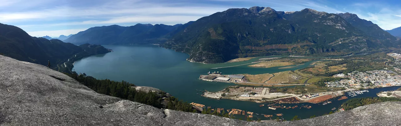
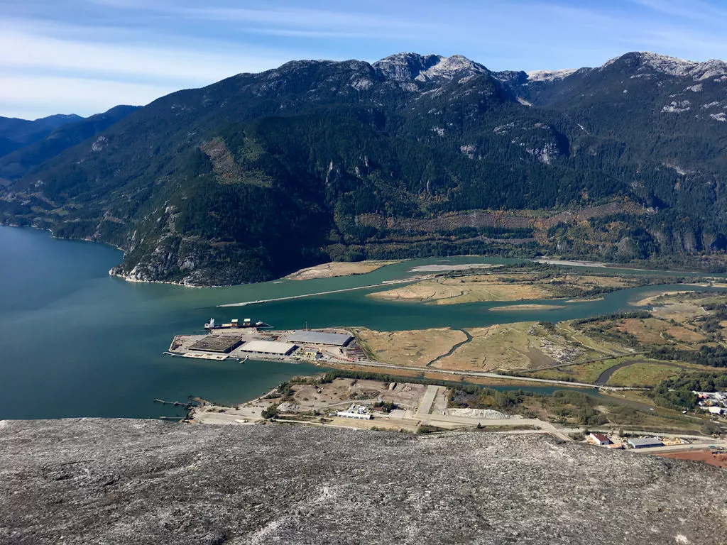
The Stawamus Chief is one of the region's classic hikes that takes you up the steep trail to one of its three peaks, offering incredible views of the area surrounding Squamish, including Howe Sound and north to Garibaldi Provincial Park. The hike to the top is challenging in sections and there are a few places where features help assist you, including a ladder and chains, but the reward is well worth the effort.
The Chief has 3 peaks and it's possible to hike all three in the same day. If you were to hike them in order, you would have to walk part way down the trail from the first peak, then go up to the second peak from a junction. From the second peak, you can continue over the peak and it drops down into a canyon where the trail climbs to the third peak. A rough estimation of time would be 6-hours to complete on you level of fitness. Alternative, you could just go to the 1st or 2nd peaks which take roughly 2.5 hours to the top and back.
From the trailhead off the Sea To Sky Highway, walk into the forest and along the wide trail as you pass by the campsite. Don't let this trail fool you as a short distance further, you reach the wooden stairs where the challenging uphill section begins.
The trail climbs quickly to the left of Olesen Creek as you make your way up the wooden stairs, carefully passing all of the people coming back down. The first section of the trail is shared with the Sea To Summit Trail that goes to the top of the Gondola, so it can seem extra busy. Continue left at the junction uphill along the trail to the Chief as the Sea To Summit Trail heads off to the right.
A bit further up and you reach another junction which goes directly to the 3rd peak. This route is not traveled as often as the other route, so.continue to the left as you make your way up the trail. When the trail reaches another marked junction, this is where the trail goes left to the First Peak and right to the Second and Third Peak. Go left towards the First Peak and continue following the trail. Not too much further up and you reach a metal ladder that you must climb to continue towards the top.
After the ladder, the trail continues in the forest until it reaches a rock section with a chain. Use the chain to help pull yourself up the steep surface and then continue hiking up the granite mountain towards the top. There are occasional markers in the rock and some of the rock is well worn from the many hikers, so it should be fairly easy to follow the route. As you approach the top, occasionally look back at the incredible view. The top of the first peak is fairly wide open and has a great view of Howe Sound looking down towards the town of Squamish.
After enjoying the view, begin your descent back down, being careful of your footing and making sure to follow the route that you took to the top. The section with the chain is often fairly busy, so you may have to wait for others as you maneuver your way back down the rock section and into the trees. Follow the trail around and then descend down the ladder, back to the junction.
If you plan to go to the Second and/or Third Peak, follow the other trail uphill at the junction in the direction of the Second Peak. This trail continues to climb steeply. There are a couple of sections along this route that have chains to help you up the mountain and you will have to be patient on a busy day as you take turns with other hikers. Make the final ascent to the top of the Second Peak for another incredible view of the area. The second peak is slightly higher than the first and offers a different view.
To get to the Third Peak, continue up and over the second peak as you follow the trail markers as the trail descends quickly into a valley known as the Saddle. this sits between peaks two and three. Hike the trail up to the third peak for a completely different view that provides a better look at Sky Pilot Mountain and several other mountains towards the North and East.
After enjoying the view at the final peak, begin hiking back the route that you came, making your way back down the saddle. At the junction in the saddle, you have the choice of going left and skipping the Second Peak, making your way back down to the main trail via an alternate route, or you can return the way that you came by going back up to the Second Peak. Both routes return via the main trail, with the alternate route joining the main trail well below the junction for the 1st and 2nd trail.
Continue hiking back down the steep wooden steps, enjoying the sounds of the rushing water in Olesen Creek before reaching the bottom. Walk back along the wide trail, past the campsite back to the trailhead where you began.


How to get to Stawamus Chief
Estimated Driving Time from Vancouver
1 hour
The Stawamus Chief is the distinctive towering mountain that overlooks the town of Squamish north of Vancouver. To get to the Chief, take Highway #1 westbound towards Horseshoe Bay and continue onto Highway #99 (Sea to Sky Highway). Continue along the highway for the next 30-40 minutes until you reach a traffic light at near Shannon Falls. Drive straight through the traffic light, past the Sea To Sky Gondola and turn right at the exit immediately after the Gondola parking lot. Drive up the short hill and park in the parking lot. The trailhead is near the south end of the parking lot
Parking
With the Sea To Sky Gondola and Shannon Falls nearby, parking near The Chief can be busy on the weekends during the summer months. If the parking lot near the trailhead is full, there are overflow parking lots just North of the main parking lot on each side of the highway. If you park on the west side of the highway, an pedestrian overpass connects both sides. It's just a short walk from each of the overflow lots to the trailhead.
View a map of Driving directions to Stawamus Chief.

Although we try to keep information as current as possible, www.vancouvertrails.com makes no warranty or representation as to the availability, quality, fitness for purpose, conditions or accuracy of the information provided with respect to this trail or trails. The information provided herein is further subject to our Terms of Use.
Comments
Add Comment View All Comments