- Difficulty Difficult
- Time 11 hours
- Round-Trip 30km
- Elevation Gain 1520 meters
- Season July - October
- Camping Yes
- From Vancouver 1 hour 45 minutes
- Shuttle Service Parkbus
- Dog Friendly No
Trail Notice
A free Day-Use Pass is required to hike this trail beginning June 17, 2022. Reservations can be made with BC Parks.
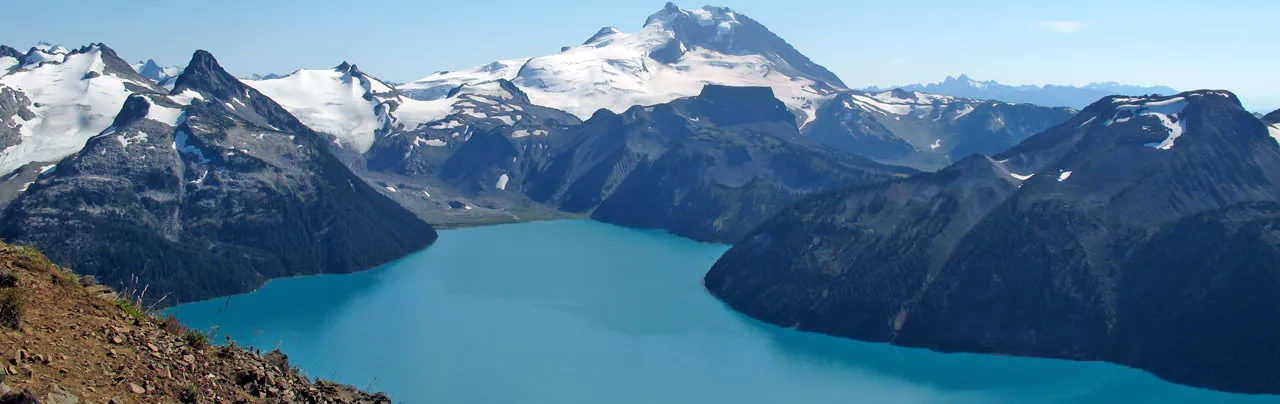
The views from Panorama Ridge are some of the most scenic views in the Garibaldi Provincial Park area. Located on the opposite end of the campsite, high above Garibaldi Lake, Panorama Ridge offers a full panoramic view of Garibaldi Lake, Black Tusk, and the Helm Lake area.
While many hikers do complete this trail in a day, the distance and elevation gain to Panorama Ridge make for a very long day. For this reason, some people prefer to hike to Garibaldi Lake or Taylor Meadows and camp overnight, before completing the hike to Panorama Ridge the following day. It is up to you which you prefer however, if you do decide to do this in a day make sure to leave plenty of time to return to the parking lot during daylight hours.
From the top section of the Rubble Creek parking lot near the wooden steps, enter the forest along the gravel trail and begin your hike. For the next 6km, the trail climbs gradually through a series of switchbacks and second growth forests. Shortly after the 6km marker, the trail reaches a junction with a map of the area. Take the trail to the left and head towards Taylor Meadows.
Another 20 minutes or so of gradual uphill and the trees begin to thin as you enter into the meadows. During the late summer or early fall, Taylor Meadows is full of bright colours from the alpine flowers that are blooming. It is important to stay along the trail in this ecologically sensitive area as some of the flowers and vegetation can take years to regrow if damaged from hikers.
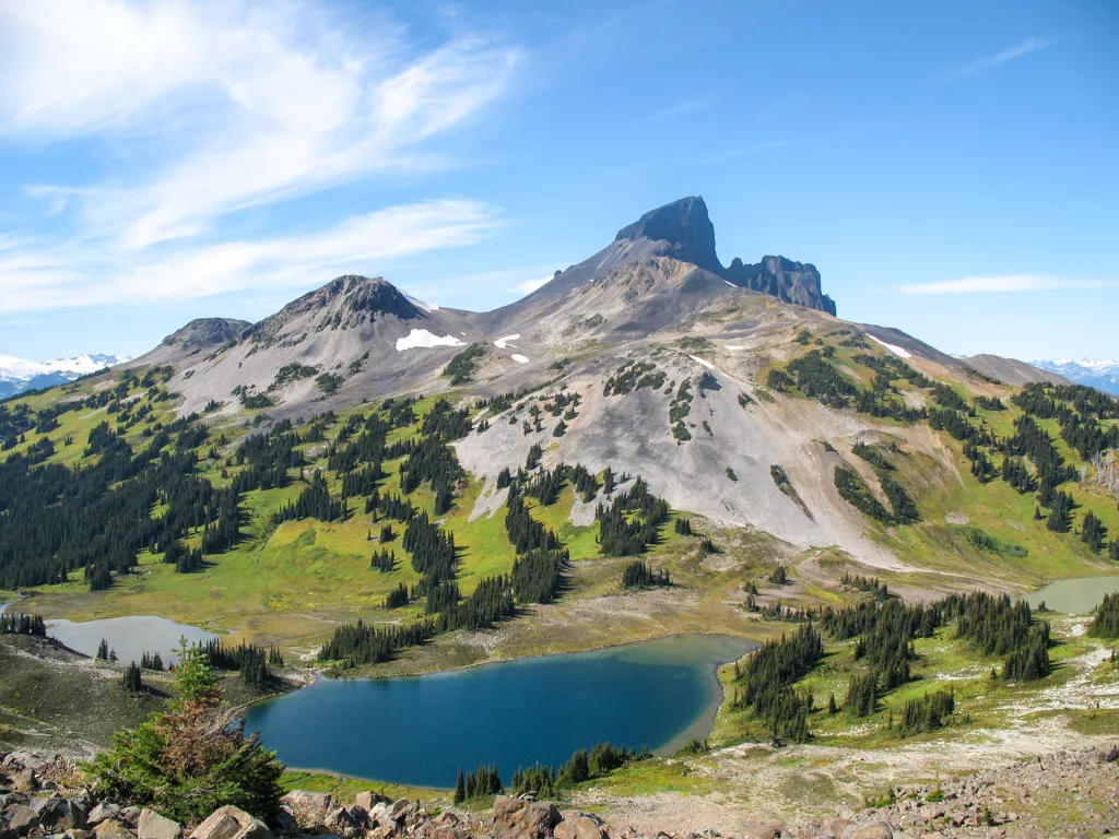
Continue along the path as just a short distance later you arrive at the Taylor Meadows campsite. Look up and to your left for a view of Black Tusk towering high above. It's inviting however, this hike will be saved for another day.
Keep continuing straight along the trail as it wanders through the meadows, occasionally looking back to catch glimpses of the snowcapped mountains behind you. Another 20 minutes or so of gradual uphill through the meadows and you arrive at the Black Tusk junction. Continue heading straight towards the Panorama Ridge junction as the trail continues alongside a slope that trickles with little streams flowing amongst the colourful flowers. As you pass through this area, observe the meadows below and the occasional rock that has slid down the hill and is now resting among the green foliage.
Eventually, the trail reaches the Panorama Ridge junction where a scenic view of Helm Lake lies off to the left. Continuing along that trail would eventually bring you to Cheakamus Lake. However, this route is better done by performing a car-swap whereby one hiking party parks a car at Rubble Creek, and another hiking party parks a car at Cheakamus Lake, then both parties hike and meet at about the midpoint of the trail where car keys are exchanged before continuing along their routes to the opposing parking lots. Instead, follow the route to Panorama Ridge by continuing to the right of the junction, heading down a slight slope before veering to the left and beginning a climb through the alpine vegetation.
The climb becomes steeper and steeper the further you continue. Enjoy the gradual climb as the steepest section is yet to come. The trail snakes up the side of the hill, eventually onto a ridge where the vegetation starts to thin and the terrain eventually becomes all rocks.
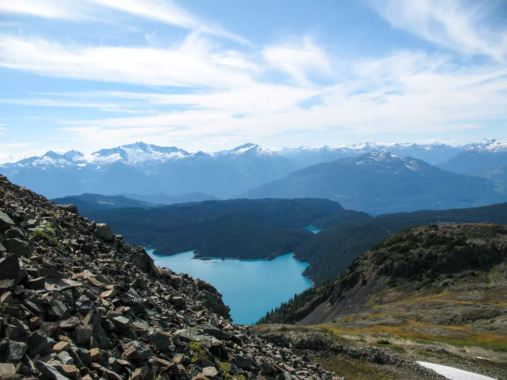
Scramble up the rocky slopes using your hands for extra help and being careful of the occasional loose rock. The trail is not marked as obvious through this area, however occasional markings and obvious wear from all the hikers lead the way to the top. The steep section can be quite grueling but keep in mind the payoff at the end is extremely rewarding. After scrambling for what seems an eternity, the trail begins to level and the turquoise colour of Garibaldi Lake appears below. At this point, you have reached your destination. The Black Tusk and Helm Lake areas lie behind and even a glimpse of the glacier next to Garibaldi Lake is visible off in the distance.
After taking in the view and being watchful of the time, head back in the direction you came from and carefully begin your descent back down the rocky slopes. Watch for trail markings as the trail becomes more obvious as you reach the lower level where the vegetation is able to grow. Return to the Panorama Ridge junction and turn left to make your way alongside the scenic slopes and back into Taylor Meadows. At the main junction, if you are short on time, continue straight towards the Taylor Meadows campsite passing through it and eventually back down towards the first junction by the 6km mark. if time permits however, turn left and follow the trail as it meanders through a series of switchbacks down towards Garibaldi Lake. A short walk down a steep slope, across a small bridge, and following the trail alongside the lake, brings you to a view of Garibaldi Lake and Panorama Ridge in the top left where you were standing a couple of hours earlier. Once you have taken in the view, continue back along the shore, across the bridge, and back up the slope, turning left at the marker. Walk straight along the trail, passing two lakes in the process before meeting up with the trail junction near the 6km mark.
From the junction, continue for the next 6km as the trail gradually makes its way back downhill eventually returning to the Rubble Creek parking lot where you began your day.


How to get to Panorama Ridge
Estimated Driving Time from Vancouver
1 hour 45 minutes
To reach the Rubble Creek parking lot, the start of the trail to Panorama Ridge via the Garibaldi Lake area, take Highway #1 (Trans Canada Highway) west towards Horseshoe Bay. Just before the ferry terminal, watch for signs to Squamish and merge onto Highway #99 (Sea to Sky Highway) northbound. Continue driving along the highway until reaching the town of Squamish 45km later. At this point, it's a good idea to make sure you have enough gas, water, and food for the day as there are no other places to stop between here and the trailhead.
Continue along Highway #99 northbound towards Whistler for another 32km. Watch for Garibaldi Provincial Park signs on your right. The turnoff is a small, paved road on the right of the highway that is easy to miss. If you pass over a bridge with a large dam on the right, you have just passed it and will have to find a place to turn around and head back.
Once on the Rubble Creek Road, continue for a couple of kilometers until you reach the parking lot.
View a map of Driving directions to Panorama Ridge.
Parkbus
Parkbus provides access to Panorama Ridge. For rates, departure times, and to reserve your seat, visit the Parkbus website.

Although we try to keep information as current as possible, www.vancouvertrails.com makes no warranty or representation as to the availability, quality, fitness for purpose, conditions or accuracy of the information provided with respect to this trail or trails. The information provided herein is further subject to our Terms of Use.
Comments
Add Comment View All Comments